
Carte topographique Prato (Leventina)
Carte interactive
Cliquez sur la carte pour afficher l’altitude.
À propos de cette carte
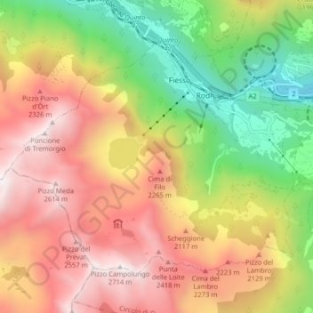
Nom : Carte topographique Prato (Leventina), altitude, relief.
Altitude moyenne : 1.755 m
Altitude minimum : 801 m
Altitude maximum : 2.688 m
The municipality is located in the Leventina district, in a depression in the mountains at an elevation of 1,046 m (3,432 ft) near the Monte Piottino gorge. It consists of the village of Prato and the hamlets of Fiesso, Mascengo, Rodi and Morasco.
Autres cartes topographiques
Cliquez sur une carte pour visualiser sa topographie, son altitude et son relief.
Sobrio
Switzerland > Ticino > Distretto di Leventina > Sobrio
Sobrio, Faido, Circolo di Giornico, Distretto di Leventina, Ticino, 6749, Switzerland
Altitude moyenne : 1.112 m
Ambrì
Switzerland > Ticino > Distretto di Leventina
Ambrì, Quinto, Circolo di Quinto, Distretto di Leventina, Ticino, 6775, Switzerland
Altitude moyenne : 1.459 m