
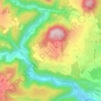
Carte topographique Sankt Johann
Carte interactive
Cliquez sur la carte pour afficher l’altitude.
À propos de cette carte
Nom : Carte topographique Sankt Johann, altitude, relief.
Altitude moyenne : 394 m
Altitude minimum : 238 m
Altitude maximum : 575 m
Autres cartes topographiques
Cliquez sur une carte pour visualiser sa topographie, son altitude et son relief.
Plaidt
Duitsland > Rijnland-Palts > Landkreis Mayen-Koblenz
Plaidt, Pellenz, Landkreis Mayen-Koblenz, Rijnland-Palts, 56637, Duitsland
Altitude moyenne : 140 m
Oberfell
Duitsland > Rijnland-Palts > Landkreis Mayen-Koblenz
Oberfell, Rhein-Mosel, Landkreis Mayen-Koblenz, Rijnland-Palts, Duitsland
Altitude moyenne : 229 m
Urmitz
Duitsland > Rijnland-Palts > Landkreis Mayen-Koblenz
Urmitz, Weißenthurm, Landkreis Mayen-Koblenz, Rijnland-Palts, Duitsland
Altitude moyenne : 67 m
Alken
Duitsland > Rijnland-Palts > Landkreis Mayen-Koblenz
Alken, Rhein-Mosel, Landkreis Mayen-Koblenz, Rijnland-Palts, Duitsland
Altitude moyenne : 216 m
Wierschem
Duitsland > Rijnland-Palts > Landkreis Mayen-Koblenz
Wierschem, Maifeld, Landkreis Mayen-Koblenz, Rijnland-Palts, Duitsland
Altitude moyenne : 228 m
Monreal
Duitsland > Rijnland-Palts > Landkreis Mayen-Koblenz > Monreal
Monreal, Vordereifel, Landkreis Mayen-Koblenz, Rijnland-Palts, Duitsland
Altitude moyenne : 384 m
Bendorf
Duitsland > Rijnland-Palts > Landkreis Mayen-Koblenz
Bendorf, Landkreis Mayen-Koblenz, Rijnland-Palts, 56170, Duitsland
Altitude moyenne : 149 m
Brodenbach
Duitsland > Rijnland-Palts > Landkreis Mayen-Koblenz
Brodenbach, Rhein-Mosel, Landkreis Mayen-Koblenz, Rijnland-Palts, Duitsland
Altitude moyenne : 227 m
Herresbach
Duitsland > Rijnland-Palts > Landkreis Mayen-Koblenz > Herresbach
Herresbach, Vordereifel, Landkreis Mayen-Koblenz, Rijnland-Palts, Duitsland
Altitude moyenne : 536 m
Acht
Duitsland > Rijnland-Palts > Landkreis Mayen-Koblenz
Acht, Vordereifel, Landkreis Mayen-Koblenz, Rijnland-Palts, Duitsland
Altitude moyenne : 519 m