
Carte topographique Coe Glacier
Carte interactive
Cliquez sur la carte pour afficher l’altitude.
À propos de cette carte
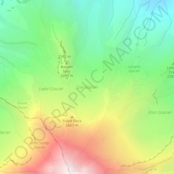
Nom : Carte topographique Coe Glacier, altitude, relief.
Lieu : Coe Glacier, Barrett Spur, Hood River County, Oregon, USA (45.37431 -121.70031 45.40296 -121.69016)
Altitude moyenne : 2.328 m
Altitude minimum : 1.644 m
Altitude maximum : 3.345 m
Autres cartes topographiques
Cliquez sur une carte pour visualiser sa topographie, son altitude et son relief.
Pearl District
Pearl District, Portland, Multnomah County, Oregon, USA
Altitude moyenne : 25 m
Skinner Glacier
Skinner Glacier, South Sister Climber Trail #36, Deschutes County, Oregon, USA
Altitude moyenne : 2.480 m
Prouty Glacier
Prouty Glacier, South Sister Climber Trail #36, Deschutes County, Oregon, USA
Altitude moyenne : 2.589 m
Reid Glacier
Reid Glacier, Yocum Ridge Trail #771, Clackamas County, Oregon, USA
Altitude moyenne : 2.410 m
Carver Glacier
Carver Glacier, South Sister Climber Trail #36, Deschutes County, Oregon, USA
Altitude moyenne : 2.385 m
Lathrop Glacier
Lathrop Glacier, Mt. Thielsen climber's trail, Douglas County, Oregon, USA
Altitude moyenne : 2.235 m
Bend Glacier
Bend Glacier, Broken Top NW Ridge route, Deschutes County, Oregon, USA
Altitude moyenne : 2.350 m
Irving Glacier
Irving Glacier, Camp Lake Trail, Deschutes County, Oregon, USA
Altitude moyenne : 2.344 m
Mount Tabor
Mount Tabor, Portland, Multnomah County, Oregon, 97215, USA
Altitude moyenne : 86 m
Jefferson Park Glacier
Jefferson Park Glacier, Pacific Crest Trail, Jefferson County, Oregon, USA
Altitude moyenne : 2.421 m
Collier Glacier
Collier Glacier, climber's trail, Deschutes County, Oregon, USA
Altitude moyenne : 2.549 m
Palmer Glacier
Palmer Glacier, Mountaineer Trail #798, Clackamas County, Oregon, USA
Altitude moyenne : 2.424 m
Zigzag Glacier
Zigzag Glacier, Mountaineer Trail #798, Clackamas County, Oregon, USA
Altitude moyenne : 2.620 m
Linn Glacier
Linn Glacier, Pacific Crest Trail, Deschutes County, Oregon, USA
Altitude moyenne : 2.359 m
Sweet Home
USA > Oregon > Sweet Home
Sweet Home, Linn County, Oregon, 97386, USA
Altitude moyenne : 230 m
Whitewater Glacier
Whitewater Glacier, Pacific Crest Trail, Jefferson County, Oregon, USA
Altitude moyenne : 2.460 m
Coalman Glacier
Coalman Glacier, Cooper Spur Trail #600B, Hood River County, Oregon, USA
Altitude moyenne : 2.728 m
Thayer Glacier
Thayer Glacier, climber's trail, Deschutes County, Oregon, USA
Altitude moyenne : 2.423 m
Renfrew Glacier
Renfrew Glacier, climber's trail, Deschutes County, Oregon, USA
Altitude moyenne : 2.538 m
Newton Clark Glacier
Newton Clark Glacier, Cooper Spur Trail #600B, Hood River County, Oregon, USA
Altitude moyenne : 2.589 m
Hayden Glacier
Hayden Glacier, climber's trail, Deschutes County, Oregon, USA
Altitude moyenne : 2.542 m
Ladd Glacier
Ladd Glacier, Barrett Spur, Hood River County, Oregon, USA
Altitude moyenne : 2.305 m
Three Fingered Jack
Three Fingered Jack, Linn County, Oregon, USA
Altitude moyenne : 1.881 m
Glisan Glacier
Glisan Glacier, McNeil Point Trail #600M, Hood River County, Oregon, USA
Altitude moyenne : 2.086 m
Eliot Glacier
Eliot Glacier, Eliot west moraine, Hood River County, Oregon, USA
Altitude moyenne : 2.316 m
Clark Glacier
Clark Glacier, South Sister Climber Trail #36, Deschutes County, Oregon, USA
Altitude moyenne : 2.578 m
Milk Creek Glacier
Milk Creek Glacier, Pacific Crest Trail, Jefferson County, Oregon, USA
Altitude moyenne : 2.508 m