
Carte topographique Hameau Cadel
Carte interactive
Cliquez sur la carte pour afficher l’altitude.
À propos de cette carte
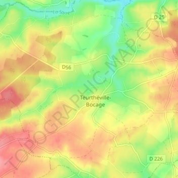
Nom : Carte topographique Hameau Cadel, altitude, relief.
Altitude moyenne : 74 m
Altitude minimum : 31 m
Altitude maximum : 111 m
Autres cartes topographiques
Cliquez sur une carte pour visualiser sa topographie, son altitude et son relief.
Hameau Gosselin
France > Normandie > Manche > Teurthéville-Bocage
Hameau Gosselin, Teurthéville-Bocage, Cherbourg, Manche, Normandie, France métropolitaine, 50630, France
Altitude moyenne : 76 m
Sainte-Croix
France > Normandie > Manche > Teurthéville-Bocage
Sainte-Croix, Teurthéville-Bocage, Cherbourg, Manche, Normandie, France métropolitaine, 50630, France
Altitude moyenne : 83 m
Le Moulin de Coisel
France > Normandie > Manche > Teurthéville-Bocage
Le Moulin de Coisel, Teurthéville-Bocage, Cherbourg, Manche, Normandie, France métropolitaine, 50630, France
Altitude moyenne : 73 m