
Carte topographique Mokoia Island
Carte interactive
Cliquez sur la carte pour afficher l’altitude.
À propos de cette carte
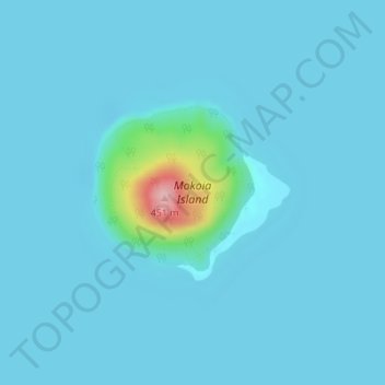
Nom : Carte topographique Mokoia Island, altitude, relief.
Altitude moyenne : 291 m
Altitude minimum : 280 m
Altitude maximum : 445 m
Autres cartes topographiques
Cliquez sur une carte pour visualiser sa topographie, son altitude et son relief.
Waipa Stream
New Zealand > Bay of Plenty > Rotorua
Waipa Stream, Tihiotonga, Rotorua, Bay of Plenty, 3010, New Zealand
Altitude moyenne : 343 m
Lake Rerewhakaaitu
New Zealand > Bay of Plenty > Rotorua
Lake Rerewhakaaitu, Rotorua, Bay of Plenty, New Zealand
Altitude moyenne : 440 m
Waikuta
New Zealand > Bay of Plenty > Rotorua > Ngongotaha > Waikuta
Waikuta, Ngongotaha, Rotorua, Bay of Plenty, 3015, New Zealand
Altitude moyenne : 324 m
Kaituna River
New Zealand > Bay of Plenty > Rotorua
Kaituna River, Rotorua, Rotorua District, Bay of Plenty, New Zealand
Altitude moyenne : 228 m
Mount Tarawera
New Zealand > Bay of Plenty > Rotorua
Mount Tarawera, Rotorua, Rotorua District, Bay of Plenty, New Zealand
Altitude moyenne : 894 m
Tarawera River
New Zealand > Bay of Plenty > Rotorua
Tarawera River, Rotorua, Rotorua District, Bay of Plenty, New Zealand
Altitude moyenne : 194 m
Lake Rotongata
New Zealand > Bay of Plenty > Rotorua
Lake Rotongata, Kaharoa Road, Rotorua, Rotorua District, Bay of Plenty, 3096, New Zealand
Altitude moyenne : 340 m
Okere Falls
New Zealand > Bay of Plenty > Rotorua
Okere Falls, Rotorua, Rotorua District, Bay of Plenty, New Zealand
Altitude moyenne : 315 m
Lake Rotokawa
New Zealand > Bay of Plenty > Rotorua
Lake Rotokawa, Te Huaki Crescent, Eastgate Business Park, Hannahs Bay, Rotorua, Rotorua District, Bay of Plenty, 3042, New Zealand
Altitude moyenne : 306 m