
Carte topographique Rheinwald
Carte interactive
Cliquez sur la carte pour afficher l’altitude.
À propos de cette carte
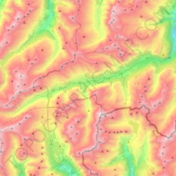
Nom : Carte topographique Rheinwald, altitude, relief.
Lieu : Rheinwald, Viamala, Grisons, Switzerland (46.47631 9.03896 46.58696 9.37331)
Altitude moyenne : 2.185 m
Altitude minimum : 972 m
Altitude maximum : 3.220 m
Autres cartes topographiques
Cliquez sur une carte pour visualiser sa topographie, son altitude et son relief.
Büel
Switzerland > Grisons > Viamala > Avers
Büel, Avers, Viamala, Grisons, 7447, Switzerland
Altitude moyenne : 2.648 m
Juf
Switzerland > Grisons > Viamala > Avers
Juf, Avers, Viamala, Grisons, 7448, Switzerland
Altitude moyenne : 2.469 m
Fürstenaubruck
Switzerland > Grisons > Viamala
Fürstenaubruck, Fürstenau, Viamala, Grisons, 7413, Switzerland
Altitude moyenne : 818 m
Splügen Pass
Switzerland > Grisons > Viamala > Rheinwald
Splügen Pass, Rheinwald, Viamala, Grisons, 7435, Switzerland
Altitude moyenne : 2.243 m
Tomils
Switzerland > Grisons > Viamala > Domleschg
Tomils, Domleschg, Viamala, Grisons, 7418, Switzerland
Altitude moyenne : 990 m
Mathon
Switzerland > Grisons > Viamala > Muntogna da Schons
Mathon, Muntogna da Schons, Viamala, Grisons, 7433, Switzerland
Altitude moyenne : 1.994 m