
Carte topographique Sonoma County
Carte interactive
Cliquez sur la carte pour afficher l’altitude.
À propos de cette carte
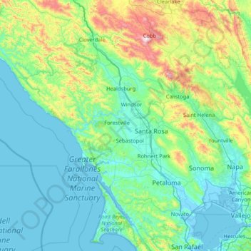
Nom : Carte topographique Sonoma County, altitude, relief.
Lieu : Sonoma County, California, United States of America (38.06953 -123.63250 38.85265 -122.34970)
Altitude moyenne : 210 m
Altitude minimum : -4 m
Altitude maximum : 1.426 m
Sonoma County, as is often the case with coastal counties in California, has a great degree of climatic variation and numerous, often very different, microclimates. Key determining factors for local climate are proximity to the ocean, elevation, and the presence and elevation of hills or mountains to the east and west. This is in large part due to the fact that, as throughout California, the prevailing weather systems and wind come normally from the Pacific Ocean, blowing in from the west and southwest so that places closer to the ocean and on the windward side of higher elevations tend to receive more rain from autumn through spring and more summer wind and fog. This itself is partly a result of the presence of high and low pressures in inland California, with persistent high summer temperatures in the Central Valley, in particular, leading to low pressures, drawing in moist air from the Pacific, cooling into damp cool breezes and fog over the cold coastal water. Those places further inland and particularly in the lee of significant elevations tend to receive less rain and less, in some cases no, fog in the summer.
Autres cartes topographiques
Cliquez sur une carte pour visualiser sa topographie, son altitude et son relief.
Glendale
United States of America > California > Glendale
Glendale, Los Angeles County, California, United States of America
Altitude moyenne : 433 m
Alpine County
United States of America > California
Alpine County, California, United States of America
Altitude moyenne : 2.216 m
Piedmont
United States of America > California > Piedmont
Piedmont, Alameda County, California, 94611, United States of America
Altitude moyenne : 97 m