
Carte topographique Horley
Carte interactive
Cliquez sur la carte pour afficher l’altitude.
À propos de cette carte
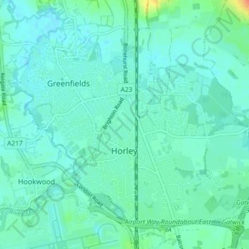
Nom : Carte topographique Horley, altitude, relief.
Lieu : Horley, Reigate and Banstead, Surrey, England, United Kingdom (51.15959 -0.19230 51.19230 -0.12775)
Altitude moyenne : 58 m
Altitude minimum : 50 m
Altitude maximum : 92 m
Horley is at an altitude of around 54 metres above mean sea level.
Autres cartes topographiques
Cliquez sur une carte pour visualiser sa topographie, son altitude et son relief.
Redhill
United Kingdom > England > Surrey > Reigate and Banstead
Redhill, Reigate and Banstead, Surrey, England, RH1 1RJ, United Kingdom
Altitude moyenne : 107 m
Nork Park
United Kingdom > England > Surrey > Reigate and Banstead > Banstead
Nork Park, Nork, Banstead, Reigate and Banstead, Surrey, England, KT18 5XE, United Kingdom
Altitude moyenne : 143 m
Burgh Heath
United Kingdom > England > Surrey > Reigate and Banstead
Burgh Heath, Reigate and Banstead, Surrey, England, KT20 5NJ, United Kingdom
Altitude moyenne : 143 m
Banstead Wood
United Kingdom > England > Surrey > Reigate and Banstead > Chipstead
Banstead Wood, Chipstead, Reigate and Banstead, Surrey, England, United Kingdom
Altitude moyenne : 145 m
St John's
United Kingdom > England > Surrey > Reigate and Banstead > Redhill
St John's, Meadvale, Redhill, Reigate and Banstead, Surrey, England, RH1 6QD, United Kingdom
Altitude moyenne : 87 m
Reigate
United Kingdom > England > Surrey > Reigate and Banstead
Reigate, Reigate and Banstead, Surrey, England, RH2 0AA, United Kingdom
Altitude moyenne : 100 m
Redhill Common
United Kingdom > England > Surrey > Reigate and Banstead > Redhill
Redhill Common, Meadvale, Redhill, Reigate and Banstead, Surrey, England, United Kingdom
Altitude moyenne : 92 m
Lower Kingswood
United Kingdom > England > Surrey > Reigate and Banstead
Lower Kingswood, Reigate and Banstead, Surrey, England, KT20 7AA, United Kingdom
Altitude moyenne : 170 m
Banstead
United Kingdom > England > Surrey > Reigate and Banstead
Banstead, Reigate and Banstead, Surrey, England, United Kingdom
Altitude moyenne : 142 m
Netherne-on-the-Hill
United Kingdom > England > Surrey > Reigate and Banstead
Netherne-on-the-Hill, Reigate and Banstead, Surrey, England, CR5 1NZ, United Kingdom
Altitude moyenne : 153 m
Reigate Hill
United Kingdom > England > Surrey > Reigate and Banstead
Reigate Hill, Reigate and Banstead, Surrey, England, RH2 9RN, United Kingdom
Altitude moyenne : 157 m
Lower Earlswood Lake
United Kingdom > England > Surrey > Reigate and Banstead > Redhill
Lower Earlswood Lake, Meadvale, Redhill, Reigate and Banstead, Surrey, South East England, England, United Kingdom
Altitude moyenne : 75 m
Salfords
United Kingdom > England > Surrey > Reigate and Banstead
Salfords, Reigate and Banstead, Surrey, England, RH1 5DG, United Kingdom
Altitude moyenne : 64 m
Norwood Hill
United Kingdom > England > Surrey > Reigate and Banstead > Norwood Hill
Norwood Hill, Reigate and Banstead, Surrey, South East England, England, RH6 0ET, United Kingdom
Altitude moyenne : 71 m
Tadworth
United Kingdom > England > Surrey > Reigate and Banstead
Tadworth, Reigate and Banstead, Surrey, England, KT20 5SW, United Kingdom
Altitude moyenne : 159 m