
Carte topographique Detroit
Carte interactive
Cliquez sur la carte pour afficher l’altitude.
À propos de cette carte
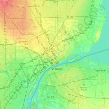
Nom : Carte topographique Detroit, altitude, relief.
Lieu : Detroit, Wayne County, Michigan, United States (42.25519 -83.28796 42.45040 -82.91044)
Altitude moyenne : 187 m
Altitude minimum : 169 m
Altitude maximum : 217 m
The city slopes gently from the northwest to southeast on a till plain composed largely of glacial and lake clay. The most notable topographical feature in the city is the Detroit Moraine, a broad clay ridge on which the older portions of Detroit and Windsor are located, rising approximately 62 feet (19 m) above the river at its highest point. The highest elevation in the city is directly north of Gorham Playground on the northwest side approximately three blocks south of 8 Mile Road, at a height of 675 to 680 feet (206 to 207 m). Detroit's lowest elevation is along the Detroit River, at a surface height of 572 feet (174 m).
Autres cartes topographiques
Cliquez sur une carte pour visualiser sa topographie, son altitude et son relief.
Redford Charter Township
United States > Michigan > Wayne County
Redford Charter Township, Wayne County, Michigan, 48239, United States
Altitude moyenne : 195 m