
Carte topographique Belagavi
Cliquez sur la carte pour afficher l’altitude.
Belagavi
Belgaum is located at 15°52′N 74°30′E / 15.87°N 74.5°E / 15.87; 74.5. It has an average elevation of 751 metres (2,464 feet). The city is in the northwestern parts of Karnataka and lies at the border of two states, Maharashtra and Goa on the western ghats (50 km (31 mi) from the Goa state border). It is one of the oldest towns in the state, lying 502 km (312 mi) from Bangalore, 500 km (310 mi) from Mumbai, 515 km (320 mi) from Hyderabad, and 600 km (370 mi) from Mysore. The district comprises 1278 villages with an area of 31,415 km2 (12,129 sq mi) and a population of around 4.8 million according to the census of 2011. Belgaum district is the biggest district of Karnataka. Situated near the foothills of the Sahyadri mountain range (Western Ghats) at an altitude of about 779 m (2,556 ft), 100 km (62 mi) from the Arabian Sea with the Markandeya river flowing nearby, Belgaum exhibits swift and kaleidoscopic changes in topography, vegetation and climate.
À propos de cette carte
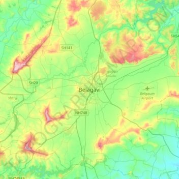
Nom : Carte topographique Belagavi, altitude, relief.
Lieu : Belagavi, Belagavi taluku, Belagavi, Karnataka, 590001, India (15.69727 74.34693 16.01727 74.66693)
Altitude moyenne : 760 m
Altitude minimum : 644 m
Altitude maximum : 1.018 m