
Faire un don
Équipez-vous pour votre prochaine aventure :
En tant que Partenaire Amazon, ce site perçoit une commission sur les achats éligibles sans surcoût pour vous.
Carte topographique Latehar
Cliquez sur la carte pour afficher l’altitude.
Faire un don
Équipez-vous pour votre prochaine aventure :
En tant que Partenaire Amazon, ce site perçoit une commission sur les achats éligibles sans surcoût pour vous.
À propos de cette carte
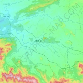
Nom : Carte topographique Latehar, altitude, relief.
Lieu : Latehar, Jharkhand, 829206, India (23.61506 84.37225 23.86932 84.64524)
Altitude moyenne : 452 m
Altitude minimum : 325 m
Altitude maximum : 1.015 m
Faire un don
Équipez-vous pour votre prochaine aventure :
En tant que Partenaire Amazon, ce site perçoit une commission sur les achats éligibles sans surcoût pour vous.
Autres cartes topographiques
Cliquez sur une carte pour visualiser sa topographie, son altitude et son relief.
Dumri
In the southern portion of Gumla district, there are flat topped hills called pat, with an elevation ranging from 2,500 feet to 3,000 feet. The pat region is spread across Bishunpur, Chainpur and Ghaghra CD blocks. The highest areas are Netarhat pat (3,356 ft), Lamiti pat (3,777 ft) and Galgat pat (3,823 ft).…
Altitude moyenne : 748 m
Faire un don
Équipez-vous pour votre prochaine aventure :
En tant que Partenaire Amazon, ce site perçoit une commission sur les achats éligibles sans surcoût pour vous.
Faire un don
Équipez-vous pour votre prochaine aventure :
En tant que Partenaire Amazon, ce site perçoit une commission sur les achats éligibles sans surcoût pour vous.
Faire un don
Équipez-vous pour votre prochaine aventure :
En tant que Partenaire Amazon, ce site perçoit une commission sur les achats éligibles sans surcoût pour vous.
Giridih
Giridih is located at 24°11′N 86°18′E / 24.18°N 86.3°E / 24.18; 86.3. It has an average elevation of 289 metres (948 ft). Śrī Sammed Shikharji also known as the Parasnath Hills, located in Giridih district is the highest mountain peak in Jharkhand. It is a conical granite peak located 4,477…
Altitude moyenne : 292 m
Faire un don
Équipez-vous pour votre prochaine aventure :
En tant que Partenaire Amazon, ce site perçoit une commission sur les achats éligibles sans surcoût pour vous.
Faire un don
Équipez-vous pour votre prochaine aventure :
En tant que Partenaire Amazon, ce site perçoit une commission sur les achats éligibles sans surcoût pour vous.
Faire un don
Équipez-vous pour votre prochaine aventure :
En tant que Partenaire Amazon, ce site perçoit une commission sur les achats éligibles sans surcoût pour vous.
Faire un don
Équipez-vous pour votre prochaine aventure :
En tant que Partenaire Amazon, ce site perçoit une commission sur les achats éligibles sans surcoût pour vous.
Faire un don
Équipez-vous pour votre prochaine aventure :
En tant que Partenaire Amazon, ce site perçoit une commission sur les achats éligibles sans surcoût pour vous.
Medininagar
India > Jharkhand > Medininagar(Daltonganj) > Medininagar
Medininagar is located at 24°02′N 84°04′E / 24.03°N 84.07°E / 24.03; 84.07. It has an average elevation of 215 m (705 ft).
Altitude moyenne : 226 m
Faire un don
Équipez-vous pour votre prochaine aventure :
En tant que Partenaire Amazon, ce site perçoit une commission sur les achats éligibles sans surcoût pour vous.
Faire un don
Équipez-vous pour votre prochaine aventure :
En tant que Partenaire Amazon, ce site perçoit une commission sur les achats éligibles sans surcoût pour vous.