
Carte topographique Marshall County
Carte interactive
Cliquez sur la carte pour afficher l’altitude.
À propos de cette carte
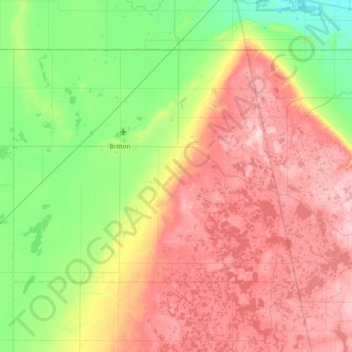
Nom : Carte topographique Marshall County, altitude, relief.
Lieu : Marshall County, South Dakota, United States (45.55816 -97.97964 45.93588 -97.22693)
Altitude moyenne : 468 m
Altitude minimum : 349 m
Altitude maximum : 634 m
Autres cartes topographiques
Cliquez sur une carte pour visualiser sa topographie, son altitude et son relief.
Black Hills
United States > South Dakota > Pennington County
Black Hills, Pennington County, South Dakota, United States
Altitude moyenne : 1.894 m
Red Shirt Table
United States > South Dakota > Oglala Lakota County
Red Shirt Table, White Clay District, Oglala Lakota County, South Dakota, United States
Altitude moyenne : 932 m
Sage Creek Basin Overlook
United States > South Dakota > Pennington County
Sage Creek Basin Overlook, Rim Road, Pennington County, South Dakota, United States
Altitude moyenne : 869 m
Sage Creek
United States > South Dakota > Pennington County
Sage Creek, Pennington County, South Dakota, United States
Altitude moyenne : 865 m
Mount Rushmore
United States > South Dakota > Pennington County
Mount Rushmore, Pennington County, South Dakota, 57751, United States
Altitude moyenne : 1.562 m
Moon
United States > South Dakota > Pennington County
Moon, Pennington County, South Dakota, United States
Altitude moyenne : 1.938 m
Bridgewater
United States > South Dakota > McCook County
Bridgewater, Bridgewater Township, McCook County, South Dakota, United States
Altitude moyenne : 432 m
South Buttes Dam
United States > South Dakota > Harding County
South Buttes Dam, Harding County, South Dakota, United States
Altitude moyenne : 910 m
Duck Creek Dam Number 2
United States > South Dakota > Fall River County
Duck Creek Dam Number 2, Fall River County, South Dakota, United States
Altitude moyenne : 1.132 m
District 6
United States > South Dakota > Dewey County
District 6, Dewey County, South Dakota, 57652, United States
Altitude moyenne : 575 m
Rapid Creek
United States > South Dakota > Pennington County
Rapid Creek, Pennington County, South Dakota, United States
Altitude moyenne : 1.689 m
Lawrence County
Lawrence County, South Dakota, United States
Altitude moyenne : 1.506 m
Harding County
Harding County, South Dakota, United States
Altitude moyenne : 930 m
Custer State Park
United States > South Dakota > Custer County
Custer State Park, Custer County, South Dakota, United States
Altitude moyenne : 1.413 m
Sanborn County
Sanborn County, South Dakota, United States
Altitude moyenne : 397 m
Sturgis
United States > South Dakota > Meade County
Sturgis, Meade County, South Dakota, United States
Altitude moyenne : 1.127 m
Haakon County
Haakon County, South Dakota, 57553, United States
Altitude moyenne : 687 m
Hand County
Hand County, South Dakota, United States
Altitude moyenne : 500 m
Lincoln County
Lincoln County, South Dakota, United States
Altitude moyenne : 418 m
Buffalo County
Buffalo County, South Dakota, United States
Altitude moyenne : 520 m
Corson County
Corson County, South Dakota, United States
Altitude moyenne : 637 m
Miner County
Miner County, South Dakota, United States
Altitude moyenne : 456 m
District 2
United States > South Dakota > Ziebach County
District 2, Ziebach County, South Dakota, United States
Altitude moyenne : 710 m
Baltic
United States > South Dakota > Minnehaha County
Baltic, Sverdup Township, Minnehaha County, South Dakota, United States
Altitude moyenne : 454 m
Winner
United States > South Dakota > Tripp County
Winner, Tripp County, South Dakota, United States
Altitude moyenne : 609 m
Ree Township
United States > South Dakota > Charles Mix County
Ree Township, Charles Mix County, South Dakota, United States
Altitude moyenne : 441 m
De Smet
United States > South Dakota > Kingsbury County
De Smet, Kingsbury County, South Dakota, 57231, United States
Altitude moyenne : 525 m
Rapid City
United States > South Dakota > Pennington County
Rapid City, Pennington County, South Dakota, United States
Altitude moyenne : 1.068 m
Swett
United States > South Dakota > Bennett County
Swett, Pass Creek District, Bennett County, South Dakota, United States
Altitude moyenne : 1.029 m
Northeast Fall River
United States > South Dakota > Fall River County
Northeast Fall River, Fall River County, South Dakota, United States
Altitude moyenne : 1.033 m
Lakota Lake
United States > South Dakota > Custer County
Lakota Lake, Custer County, South Dakota, United States
Altitude moyenne : 1.409 m
Mount Rushmore National Memorial
United States > South Dakota > Pennington County
Mount Rushmore National Memorial, Pennington County, South Dakota, United States
Altitude moyenne : 1.528 m
Porcupine
United States > South Dakota > Oglala Lakota County
Porcupine, Porcupine District, Oglala Lakota County, South Dakota, 57772, United States
Altitude moyenne : 1.013 m
Badlands National Park
United States > South Dakota > Oglala Lakota County
Badlands National Park, Oglala Lakota County, South Dakota, 57750, United States
Altitude moyenne : 848 m
Pennington County
Pennington County, South Dakota, United States
Altitude moyenne : 960 m
Madison
United States > South Dakota > Lake County
Madison, Lake County, South Dakota, United States
Altitude moyenne : 516 m
Terry Peak
United States > South Dakota > Lawrence County
Terry Peak, Lawrence County, South Dakota, United States
Altitude moyenne : 1.940 m
Aurora County
Aurora County, South Dakota, United States
Altitude moyenne : 479 m
Sioux Falls
United States > South Dakota > Minnehaha County
Sioux Falls, Sioux Falls Township, Minnehaha County, South Dakota, United States
Altitude moyenne : 445 m
Bourne Slough
United States > South Dakota > Lake County > Chautauqua
Bourne Slough, Chautauqua, Lake County, South Dakota, United States
Altitude moyenne : 496 m
Doland
United States > South Dakota > Spink County > Doland
Doland, Spink County, South Dakota, 57436, United States
Altitude moyenne : 416 m
Lyman County
Lyman County, South Dakota, United States
Altitude moyenne : 539 m
Wlliam T Malloy Dam
United States > South Dakota > Perkins County
Wlliam T Malloy Dam, Perkins County, South Dakota, United States
Altitude moyenne : 758 m
Summit
United States > South Dakota > Roberts County > Summit
Summit, Roberts County, South Dakota, United States
Altitude moyenne : 609 m
Olsonville
United States > South Dakota > Todd County > Olsonville
Olsonville, Todd County, South Dakota, United States
Altitude moyenne : 855 m
John Penor Dam
United States > South Dakota > Perkins County
John Penor Dam, Perkins County, South Dakota, 57620, United States
Altitude moyenne : 813 m
Moody County
United States > South Dakota > Moody County
Moody County, South Dakota, United States
Altitude moyenne : 498 m
Spearfish
United States > South Dakota > Lawrence County > Spearfish
Spearfish, Lawrence County, South Dakota, 57783, United States
Altitude moyenne : 1.291 m
Watertown
United States > South Dakota > Codington County > Watertown
Watertown, Codington County, South Dakota, 57201, United States
Altitude moyenne : 550 m
Sisseton
United States > South Dakota > Roberts County > Sisseton
Sisseton, Long Hollow District, Roberts County, South Dakota, 57262, United States
Altitude moyenne : 381 m