
Faire un don
Équipez-vous pour votre prochaine aventure :
En tant que Partenaire Amazon, ce site perçoit une commission sur les achats éligibles sans surcoût pour vous.
Carte topographique Kiveton Park
Cliquez sur la carte pour afficher l’altitude.
Faire un don
Équipez-vous pour votre prochaine aventure :
En tant que Partenaire Amazon, ce site perçoit une commission sur les achats éligibles sans surcoût pour vous.
Kiveton Park
Kiveton Park is located at approximately 53°20′30″N 1°15′30″W / 53.34167°N 1.25833°W / 53.34167; -1.25833, at an elevation of around 330 feet (100 m) above sea level, and is located 8 miles (13 km) west of Worksop, and 11 miles (18 km) south-east of both Sheffield, and Rotherham respectively. It lies on the B6059 road (Station Road) and is served by two railway stations: Kiveton Bridge and Kiveton Park. The Chesterfield Canal lies to the south, while the villages of Todwick and South Anston are to the north and east. Kiveton Park lays claim to being in Rotherham Borough Council, has a Sheffield postcode, a Worksop telephone code, and has the Chesterfield Canal running through it. The village has two railway stations: Kiveton Bridge railway station in the centre of the village; and Kiveton Park railway station.
Faire un don
Équipez-vous pour votre prochaine aventure :
En tant que Partenaire Amazon, ce site perçoit une commission sur les achats éligibles sans surcoût pour vous.
À propos de cette carte
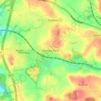
Nom : Carte topographique Kiveton Park, altitude, relief.
Altitude moyenne : 104 m
Altitude minimum : 71 m
Altitude maximum : 135 m
Faire un don
Équipez-vous pour votre prochaine aventure :
En tant que Partenaire Amazon, ce site perçoit une commission sur les achats éligibles sans surcoût pour vous.
Autres cartes topographiques
Cliquez sur une carte pour visualiser sa topographie, son altitude et son relief.
Faire un don
Équipez-vous pour votre prochaine aventure :
En tant que Partenaire Amazon, ce site perçoit une commission sur les achats éligibles sans surcoût pour vous.
Hellaby
United Kingdom > England > Rotherham
With a Dutch impression that was influenced by the style common in the colonies, the Hall was built on a hill and hence an extra storey was required to obtain the height at the front elevation.
Altitude moyenne : 113 m
Thorpe Salvin
United Kingdom > England > Rotherham
Thorpe Salvin is a village and a civil parish in the Metropolitan Borough of Rotherham in South Yorkshire, England, on the border with Nottinghamshire. It lies between Worksop and Harthill, and is located at an elevation of around 110 metres above sea level. At the 2011 Census, it had a population of 476, down…
Altitude moyenne : 102 m
Faire un don
Équipez-vous pour votre prochaine aventure :
En tant que Partenaire Amazon, ce site perçoit une commission sur les achats éligibles sans surcoût pour vous.
Woodsetts
United Kingdom > England > Rotherham
Woodsetts is a village and civil parish in the Metropolitan Borough of Rotherham in South Yorkshire, England, on the border with Nottinghamshire. It lies between the towns of Dinnington and Worksop at an elevation of around 60 metres above sea level, and has a population of 1,746 at the 2011 Census. The…
Altitude moyenne : 70 m
Faire un don
Équipez-vous pour votre prochaine aventure :
En tant que Partenaire Amazon, ce site perçoit une commission sur les achats éligibles sans surcoût pour vous.
Faire un don
Équipez-vous pour votre prochaine aventure :
En tant que Partenaire Amazon, ce site perçoit une commission sur les achats éligibles sans surcoût pour vous.
Sheffield and South Yokshire Navigation
United Kingdom > England > Rotherham > Thrybergh
Altitude moyenne : 39 m
Faire un don
Équipez-vous pour votre prochaine aventure :
En tant que Partenaire Amazon, ce site perçoit une commission sur les achats éligibles sans surcoût pour vous.