
Carte topographique Argelaguer
Carte interactive
Cliquez sur la carte pour afficher l’altitude.
À propos de cette carte
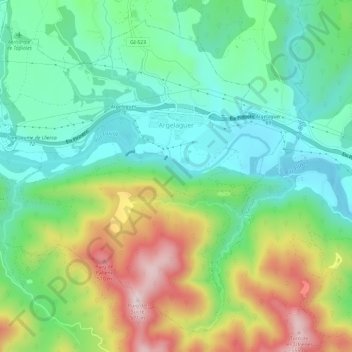
Nom : Carte topographique Argelaguer, altitude, relief.
Lieu : Argelaguer, Garrotxa, Gerona, Cataluña, 17853, España (42.18890 2.60119 42.22753 2.65976)
Altitude moyenne : 287 m
Altitude minimum : 150 m
Altitude maximum : 548 m
Autres cartes topographiques
Cliquez sur une carte pour visualiser sa topographie, son altitude et son relief.
Sagrat Cor
España > Cataluña > Garrotxa > Besalú
Sagrat Cor, Carrer Montserrat Vayreda, Besalú, Garrotxa, Gerona, Cataluña, 17850, España
Altitude moyenne : 274 m
la Vall de Bianya
la Vall de Bianya, Garrotxa, Gerona, Cataluña, 17813, España
Altitude moyenne : 722 m
Santa Margarida de Bianya
España > Cataluña > Garrotxa > la Vall de Bianya > l'Hostalnou de Bianya
Santa Margarida de Bianya, l'Hostalnou de Bianya, la Vall de Bianya, Garrotxa, Gerona, Cataluña, 17813, España
Altitude moyenne : 467 m
Castellfollit de la Roca
Castellfollit de la Roca, Garrotxa, Gerona, Cataluña, 17856, España
Altitude moyenne : 389 m
les Planes d'Hostoles
les Planes d'Hostoles, Garrotxa, Gerona, Cataluña, 17172, España
Altitude moyenne : 601 m
Oix
España > Cataluña > Garrotxa > Montagut i Oix
Oix, Montagut i Oix, Garrotxa, Gerona, Cataluña, 17856, España
Altitude moyenne : 572 m
la Vall d'en Bas
la Vall d'en Bas, Garrotxa, Gerona, Cataluña, España
Altitude moyenne : 758 m
Sant Aniol de Finestres
Sant Aniol de Finestres, Garrotxa, Gerona, Cataluña, 17154, España
Altitude moyenne : 484 m
Sant Jaume de Llierca
Sant Jaume de Llierca, Garrotxa, Gerona, Cataluña, 17854, España
Altitude moyenne : 274 m
Puigsacalm
España > Cataluña > Garrotxa > la Vall d'en Bas
Puigsacalm, Camí de la Font Tornadissa, la Vall d'en Bas, Garrotxa, Gerona, Cataluña, España
Altitude moyenne : 1.117 m
Reserva natural parcial de la Fageda d'en Jordà
España > Cataluña > Garrotxa > Olot
Reserva natural parcial de la Fageda d'en Jordà, Olot, Garrotxa, Gerona, Cataluña, 17811, España
Altitude moyenne : 588 m
Castellfollit de la Roca
España > Cataluña > Garrotxa > Castellfollit de la Roca > Castellfollit de la Roca
Castellfollit de la Roca, Garrotxa, Gerona, Cataluña, 17856, España
Altitude moyenne : 394 m
Fageda de la Bernadella
España > Cataluña > Garrotxa > Santa Pau
Fageda de la Bernadella, Santa Pau, Garrotxa, Gerona, Cataluña, 17811, España
Altitude moyenne : 739 m
les Preses
les Preses, Garrotxa, Gerona, Cataluña, España
Altitude moyenne : 520 m
Sant Feliu de Pallerols
España > Cataluña > Garrotxa > Sant Feliu de Pallerols
Sant Feliu de Pallerols, Garrotxa, Gerona, Cataluña, 17174, España
Altitude moyenne : 642 m
Sant Joan les Fonts
Sant Joan les Fonts, Garrotxa, Gerona, Cataluña, 17857, España
Altitude moyenne : 477 m