
Faire un don
Équipez-vous pour votre prochaine aventure :
En tant que Partenaire Amazon, ce site perçoit une commission sur les achats éligibles sans surcoût pour vous.
Carte topographique Arginonta
Cliquez sur la carte pour afficher l’altitude.
Faire un don
Équipez-vous pour votre prochaine aventure :
En tant que Partenaire Amazon, ce site perçoit une commission sur les achats éligibles sans surcoût pour vous.
À propos de cette carte
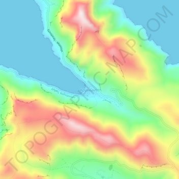
Nom : Carte topographique Arginonta, altitude, relief.
Altitude moyenne : 225 m
Altitude minimum : 0 m
Altitude maximum : 585 m
Faire un don
Équipez-vous pour votre prochaine aventure :
En tant que Partenaire Amazon, ce site perçoit une commission sur les achats éligibles sans surcoût pour vous.
Autres cartes topographiques
Cliquez sur une carte pour visualiser sa topographie, son altitude et son relief.
Kalymnos
Greece > Aegean > Kalmynos Regional Unit
Kalymnos is mostly mountainous with complicated topography. There are three main chains going from W-NW to E-SE, and a fourth which extends NW the length of the peninsula. The coastline is very irregular, with many sheltered coves. There are some springs, one among them being thermal. The soil is mainly…
Altitude moyenne : 75 m