
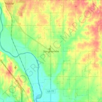
Carte topographique Slaughterville
Carte interactive
Cliquez sur la carte pour afficher l’altitude.
À propos de cette carte
Nom : Carte topographique Slaughterville, altitude, relief.
Altitude moyenne : 344 m
Altitude minimum : 314 m
Altitude maximum : 384 m
Autres cartes topographiques
Cliquez sur une carte pour visualiser sa topographie, son altitude et son relief.
Norman
United States > Oklahoma > Cleveland County
Norman, Cleveland County, Oklahoma, United States
Altitude moyenne : 358 m
Etowah
United States > Oklahoma > Cleveland County
Etowah, Cleveland County, Oklahoma, United States
Altitude moyenne : 334 m
Lexington
United States > Oklahoma > Cleveland County
Lexington, Cleveland County, Oklahoma, United States
Altitude moyenne : 321 m
Moore
United States > Oklahoma > Cleveland County
Moore, Cleveland County, Oklahoma, 73160, United States
Altitude moyenne : 373 m
Lake Thunderbird
United States > Oklahoma > Cleveland County > Norman
Lake Thunderbird, Norman, Cleveland County, Oklahoma, United States
Altitude moyenne : 334 m
Noble
United States > Oklahoma > Cleveland County
Noble, Cleveland County, Oklahoma, 73068, United States
Altitude moyenne : 344 m
Southwest Oklahoma City Sludge Lagoon Dam
United States > Oklahoma > Cleveland County > Oklahoma City
Southwest Oklahoma City Sludge Lagoon Dam, Oklahoma City, Cleveland County, Oklahoma, 73165, United States
Altitude moyenne : 348 m
Norman
United States > Oklahoma > Cleveland County > Norman
Norman, Cleveland County, Oklahoma, 73069, United States
Altitude moyenne : 356 m
Moore
United States > Oklahoma > Cleveland County > Moore > Moore
Moore, Cleveland County, Oklahoma, 73160, United States
Altitude moyenne : 377 m