
Carte topographique Sioux County
Carte interactive
Cliquez sur la carte pour afficher l’altitude.
À propos de cette carte
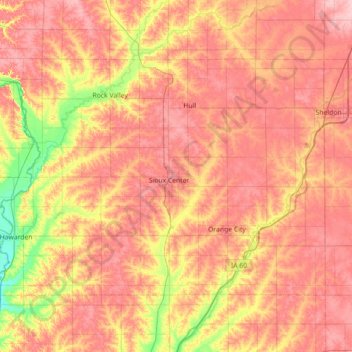
Nom : Carte topographique Sioux County, altitude, relief.
Lieu : Sioux County, Iowa, United States (42.90908 -96.57149 43.26003 -95.85839)
Altitude moyenne : 418 m
Altitude minimum : 351 m
Altitude maximum : 466 m
Autres cartes topographiques
Cliquez sur une carte pour visualiser sa topographie, son altitude et son relief.
Chatsworth
United States > Iowa > Sioux County > Chatsworth > Chatsworth
Chatsworth, Sioux County, Iowa, 51011, United States
Altitude moyenne : 359 m
Chatsworth
United States > Iowa > Sioux County
Chatsworth, Sioux County, Iowa, 51011, United States
Altitude moyenne : 357 m
Hawarden
United States > Iowa > Sioux County
Hawarden, Sioux County, Iowa, United States
Altitude moyenne : 365 m