
Carte topographique Putanges-Pont-Écrepin
Carte interactive
Cliquez sur la carte pour afficher l’altitude.
À propos de cette carte
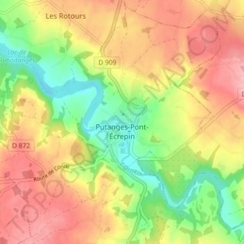
Nom : Carte topographique Putanges-Pont-Écrepin, altitude, relief.
Altitude moyenne : 186 m
Altitude minimum : 119 m
Altitude maximum : 248 m
Autres cartes topographiques
Cliquez sur une carte pour visualiser sa topographie, son altitude et son relief.
Le Val Besnard
Frankrijk > Normandië > Orne > Putanges-le-Lac > Rabodanges
Le Val Besnard, Rabodanges, Putanges-le-Lac, Argentan, Orne, Normandië, Metropolitaans Frankrijk, 61210, Frankrijk
Altitude moyenne : 176 m
Lac de Rabodanges
Frankrijk > Normandië > Orne > Putanges-le-Lac > Sainte-Croix-sur-Orne
Lac de Rabodanges, Les Caves, Sainte-Croix-sur-Orne, Putanges-le-Lac, Argentan, Orne, Normandië, Metropolitaans Frankrijk, 61210, Frankrijk
Altitude moyenne : 176 m
La Forêt-Auvray
Frankrijk > Normandië > Orne > Putanges-le-Lac
La Forêt-Auvray, Putanges-le-Lac, Argentan, Orne, Normandië, Metropolitaans Frankrijk, 61210, Frankrijk
Altitude moyenne : 187 m