
Carte topographique Harper
Cliquez sur la carte pour afficher l’altitude.
À propos de cette carte
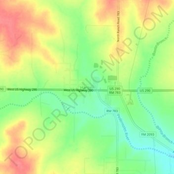
Nom : Carte topographique Harper, altitude, relief.
Lieu : Harper, Gillespie County, Texas, 78631, United States (30.28073 -99.27084 30.32073 -99.23084)
Altitude moyenne : 634 m
Altitude minimum : 599 m
Altitude maximum : 668 m
Autres cartes topographiques
Cliquez sur une carte pour visualiser sa topographie, son altitude et son relief.
Fredericksburg
United States > Texas > Gillespie County
Enchanted Rock is a geographical landmark 27 km (17 mi) north of Fredericksburg in Llano County. The rock is a huge, pink granite exfoliation dome that rises 425 ft (130 m) above the surrounding land, has a summit elevation of 1,825 ft (556 m) above sea level, and covers 640 acres (260 ha). Enchanted Rock…
Altitude moyenne : 526 m