
Faire un don
Équipez-vous pour votre prochaine aventure :
En tant que Partenaire Amazon, ce site perçoit une commission sur les achats éligibles sans surcoût pour vous.
Carte topographique Punchbowl Dome
Cliquez sur la carte pour afficher l’altitude.
Faire un don
Équipez-vous pour votre prochaine aventure :
En tant que Partenaire Amazon, ce site perçoit une commission sur les achats éligibles sans surcoût pour vous.
À propos de cette carte
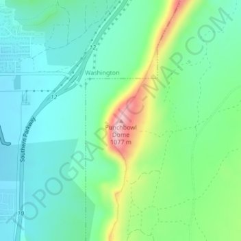
Nom : Carte topographique Punchbowl Dome, altitude, relief.
Lieu : Punchbowl Dome, Washington County, Utah, United States (37.07827 -113.47195 37.07837 -113.47185)
Altitude moyenne : 895 m
Altitude minimum : 829 m
Altitude maximum : 1.073 m
Faire un don
Équipez-vous pour votre prochaine aventure :
En tant que Partenaire Amazon, ce site perçoit une commission sur les achats éligibles sans surcoût pour vous.
Autres cartes topographiques
Cliquez sur une carte pour visualiser sa topographie, son altitude et son relief.
Zion National Park
United States > Utah > Washington County
The 8,726-foot (2,660 m) summit of Horse Ranch Mountain is the highest point in the park; the lowest point is the 3,666-foot (1,117 m) elevation of Coal Pits Wash, creating a relief of about 5,100 feet (1,600 m).
Altitude moyenne : 1.877 m
Zion National Park
United States > Utah > Washington County
The 8,726-foot (2,660 m) summit of Horse Ranch Mountain is the highest point in the park; the lowest point is the 3,666-foot (1,117 m) elevation of Coal Pits Wash, creating a relief of about 5,100 feet (1,600 m).
Altitude moyenne : 1.877 m
Saint George
United States > Utah > Washington County
The St. George valley occasionally receives wet or slushy snowfall in the winter, but what accumulates usually melts off by the mid-to-late morning; the normal seasonal snowfall is 1.4 inches (3.6 cm). The earliest snowfall was measured on October 29, 1971, and the latest on April 11, 1927. The record…
Altitude moyenne : 929 m
Faire un don
Équipez-vous pour votre prochaine aventure :
En tant que Partenaire Amazon, ce site perçoit une commission sur les achats éligibles sans surcoût pour vous.
St. George
United States > Utah > Washington County
The St. George valley occasionally receives wet or slushy snowfall in the winter, but what accumulates usually melts off by the mid-to-late morning; the normal seasonal snowfall is 1.4 inches (3.6 cm). The earliest snowfall was measured on October 29, 1971, and the latest on April 11, 1927. The record…
Altitude moyenne : 934 m
Faire un don
Équipez-vous pour votre prochaine aventure :
En tant que Partenaire Amazon, ce site perçoit une commission sur les achats éligibles sans surcoût pour vous.
Virgin
United States > Utah > Washington County
Virgin is a town in Washington County, Utah, United States. The population was 670 at the 2020 census. The first settlement at Virgin was made in 1858. It is located along the Virgin River (for which it is named), and not far from Zion National Park. The elevation is 3,606 feet (1,099 m). It lies on State…
Altitude moyenne : 1.251 m
Veyo
United States > Utah > Washington County > Veyo
The elevation of Veyo is 4,485 feet (1,367 m).
Altitude moyenne : 1.379 m
Faire un don
Équipez-vous pour votre prochaine aventure :
En tant que Partenaire Amazon, ce site perçoit une commission sur les achats éligibles sans surcoût pour vous.
Virgin
United States > Utah > Washington County
Virgin is a town in Washington County, Utah, United States. The population was 596 at the 2010 census. The first settlement at Virgin was made in 1858. It is located along the Virgin River (for which it is named), and not far from Zion National Park. The elevation is 3,606 feet (1,099 m). It lies on State…
Altitude moyenne : 1.251 m
Faire un don
Équipez-vous pour votre prochaine aventure :
En tant que Partenaire Amazon, ce site perçoit une commission sur les achats éligibles sans surcoût pour vous.
Zion National Park
United States > Utah > Washington County
The 8,726-foot (2,660 m) summit of Horse Ranch Mountain is the highest point in the park; the lowest point is the 3,666-foot (1,117 m) elevation of Coal Pits Wash, creating a relief of about 5,100 feet (1,600 m).
Altitude moyenne : 1.877 m
Zion Canyon
United States > Utah > Washington County
Geologically Zion Canyon is part of the Navajo sandstone Colorado Plateau, which contained many joints and cracks when first uplifted, one of which was cut by the North Fork of the Virgin River to become Zion Canyon. The river was the largest force in cutting the canyon, mostly by flash floods, as the average…
Altitude moyenne : 1.821 m
St. George
United States > Utah > Washington County
According to the United States Census Bureau, the city has an area of 77.151 square miles (199.82 km2), of which 0.003 square miles (0.0078 km2) (0.72% or about 2 ac) is covered by water. St. George is in a desert valley, with most of the city lying below 3,000 feet (900 m) in elevation. It is near a…
Altitude moyenne : 933 m
Virgin
United States > Utah > Washington County
Virgin is a town in Washington County, Utah, United States. The population was 596 at the 2010 census. The first settlement at Virgin was made in 1858. It is located along the Virgin River (for which it is named), and not far from Zion National Park. The elevation is 3,606 feet (1,099 m). It lies on State…
Altitude moyenne : 1.251 m
Faire un don
Équipez-vous pour votre prochaine aventure :
En tant que Partenaire Amazon, ce site perçoit une commission sur les achats éligibles sans surcoût pour vous.
St. George
United States > Utah > Washington County
According to the United States Census Bureau, the city has a total area of 77.151 square miles (199.82 km2), of which 0.003 square miles (0.0078 km2) (0.72%) is covered by water. St. George lies in a desert valley, with most of the city lying below 3,000 feet (900 m) in elevation. It is situated near a…
Altitude moyenne : 933 m
St. George
United States > Utah > Washington County
According to the United States Census Bureau, the city has an area of 77.151 square miles (199.82 km2), of which 0.003 square miles (0.0078 km2) (0.72% or about 2 ac) is covered by water. St. George is in a desert valley, with most of the city lying below 3,000 feet (900 m) in elevation. It is near a…
Altitude moyenne : 933 m
Faire un don
Équipez-vous pour votre prochaine aventure :
En tant que Partenaire Amazon, ce site perçoit une commission sur les achats éligibles sans surcoût pour vous.
Cottonwood Canyon Wilderness
United States > Utah > Washington County > Washington
Altitude moyenne : 1.213 m
Zion National Park
United States > Utah > Washington County
The 8,726-foot (2,660 m) summit of Horse Ranch Mountain is the highest point in the park; the lowest point is the 3,666-foot (1,117 m) elevation of Coal Pits Wash, creating a relief of about 5,100 feet (1,600 m).
Altitude moyenne : 1.877 m
Faire un don
Équipez-vous pour votre prochaine aventure :
En tant que Partenaire Amazon, ce site perçoit une commission sur les achats éligibles sans surcoût pour vous.
St. George
United States > Utah > Washington County
The St. George valley occasionally receives wet or slushy snowfall in the winter, but what accumulates usually melts off by the mid-to-late morning; the normal seasonal snowfall is 1.4 inches (3.6 cm). The earliest snowfall was measured on October 29, 1971, and the latest on April 11, 1927. The record…
Altitude moyenne : 933 m
Faire un don
Équipez-vous pour votre prochaine aventure :
En tant que Partenaire Amazon, ce site perçoit une commission sur les achats éligibles sans surcoût pour vous.
St. George
United States > Utah > Washington County
The St. George valley occasionally receives wet or slushy snowfall in the winter, but what accumulates usually melts off by the mid-to-late morning; the normal seasonal snowfall is 1.4 inches (3.6 cm). The earliest snowfall was measured on October 29, 1971, and the latest on April 11, 1927. The record…
Altitude moyenne : 929 m
Faire un don
Équipez-vous pour votre prochaine aventure :
En tant que Partenaire Amazon, ce site perçoit une commission sur les achats éligibles sans surcoût pour vous.
Pine Valley Mountain Wilderness
United States > Utah > Washington County
Pine Valley Mountain Wilderness is a 50,232-acre (203.28 km2) wilderness area located in the Dixie National Forest in the U.S. state of Utah. It is the fourth-largest wilderness area located entirely within the state (following the High Uintas Wilderness, Zion Wilderness, and Cedar Mountain Wilderness). The…
Altitude moyenne : 2.125 m