Géolocaliser

Carte topographique Eruthuvapuzha

Cliquez sur la carte pour afficher l’altitude.

À propos de cette carte

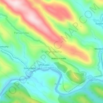
Nom : Carte topographique Eruthuvapuzha, altitude, relief.

Lieu : Eruthuvapuzha, Kanjirappally, Kottayam, Kerala, 686510, India (9.41194 76.90034 9.45194 76.94034)

Altitude moyenne : 207 m

Altitude minimum : 61 m

Altitude maximum : 468 m

Autres cartes topographiques

Cliquez sur une carte pour visualiser sa topographie, son altitude et son relief.

Elivalikkara

India > Kerala > Kanjirappally > Mukkoottuthara

Altitude moyenne : 167 m

Mundakayam

India > Kerala > Kanjirappally > Kannimala

Altitude moyenne : 132 m

Kanjirappilly

India > Kerala > Kanjirappally

Altitude moyenne : 228 m

Nadukani

India > Kerala > Kanjirappally > Mundakkayam

Altitude moyenne : 159 m

Équipez-vous pour votre prochaine aventure :

👟Chaussures de trail - Chaussures pour sentiers techniques
🦟Anti-moustiques - Protection contre les insectes
📱Coques étanches - Protection du téléphone en extérieur
Tentes de randonnée - Tentes légères pour le bivouac
🍳Popotes camping - Ustensiles de cuisine pour bivouac

En tant que Partenaire Amazon, ce site perçoit une commission sur les achats éligibles sans surcoût pour vous.