
Faire un don
Équipez-vous pour votre prochaine aventure :
En tant que Partenaire Amazon, ce site perçoit une commission sur les achats éligibles sans surcoût pour vous.
Carte topographique Mount Gongga
Cliquez sur la carte pour afficher l’altitude.
Faire un don
Équipez-vous pour votre prochaine aventure :
En tant que Partenaire Amazon, ce site perçoit une commission sur les achats éligibles sans surcoût pour vous.
Mount Gongga
Mount Gongga (simplified Chinese: 贡嘎山; traditional Chinese: 貢嘎山; pinyin: Gònggá Shān), also known as Minya Konka (Khams Tibetan: མི་ཉག་གངས་དཀར་རི་བོ་, Khams Tibetan pinyin: Mi'nyâg Gong'ga Riwo) and colloquially as "The King of Sichuan Mountains", is the highest mountain in Sichuan province, China. It has an elevation of 7,556 m (24,790 ft) above sea level. This makes it the third highest peak in the world outside of the Himalaya/Karakoram range, after Tirich Mir and Kongur Tagh, and the easternmost and most isolated 7,000-metre (23,000 ft) peak in the world. It is situated in the Daxue Shan mountain range, between Dadu River and Yalong River, and is part of the Hengduan mountainous region. From it comes the Hailuogou glacier.
Faire un don
Équipez-vous pour votre prochaine aventure :
En tant que Partenaire Amazon, ce site perçoit une commission sur les achats éligibles sans surcoût pour vous.
À propos de cette carte
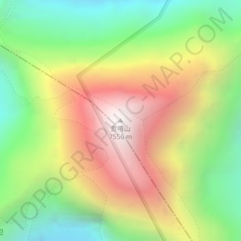
Nom : Carte topographique Mount Gongga, altitude, relief.
Lieu : Mount Gongga, Kangding, Kardze, Sichuan, 626000, China (29.59580 101.87901 29.59590 101.87911)
Altitude moyenne : 6.496 m
Altitude minimum : 5.699 m
Altitude maximum : 7.468 m
Faire un don
Équipez-vous pour votre prochaine aventure :
En tant que Partenaire Amazon, ce site perçoit une commission sur les achats éligibles sans surcoût pour vous.
Autres cartes topographiques
Cliquez sur une carte pour visualiser sa topographie, son altitude et son relief.