
Carte topographique Pollachi
Cliquez sur la carte pour afficher l’altitude.
Pollachi
Pollachi is located at 10°39′43″N 77°00′23″E / 10.662°N 77.0065°E / 10.662; 77.0065 near the center of the South Indian Peninsula, surrounded by Western Ghats. It has an average elevation of 293 metres (961 ft) on the banks of Aliyar river. The area is hilly and rocky, drained by several rivers and is thickly forested with some marsh lands and scattered patches of grass. The town receives majority of the rainfall from Southwest monsoon arriving through the Palghat gap and receives an average annual rainfall of around 1,274 mm (50.2 in).
À propos de cette carte
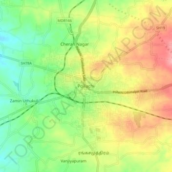
Nom : Carte topographique Pollachi, altitude, relief.
Lieu : Pollachi, Coimbatore, Tamil Nadu, 642001, India (10.61882 76.96873 10.69882 77.04873)
Altitude moyenne : 289 m
Altitude minimum : 239 m
Altitude maximum : 350 m
Autres cartes topographiques
Cliquez sur une carte pour visualiser sa topographie, son altitude et son relief.