
Faire un don
Équipez-vous pour votre prochaine aventure :
En tant que Partenaire Amazon, ce site perçoit une commission sur les achats éligibles sans surcoût pour vous.
Carte topographique Liberty
Cliquez sur la carte pour afficher l’altitude.
Faire un don
Équipez-vous pour votre prochaine aventure :
En tant que Partenaire Amazon, ce site perçoit une commission sur les achats éligibles sans surcoût pour vous.
À propos de cette carte
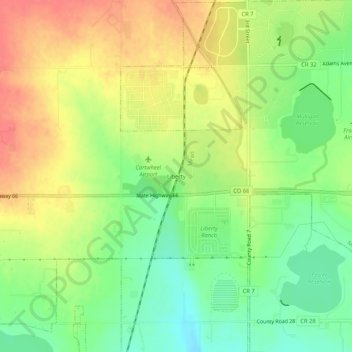
Nom : Carte topographique Liberty, altitude, relief.
Lieu : Liberty, Weld County, Colorado, 80542, United States (40.18610 -105.02915 40.22610 -104.98915)
Altitude moyenne : 1.523 m
Altitude minimum : 1.494 m
Altitude maximum : 1.552 m
Faire un don
Équipez-vous pour votre prochaine aventure :
En tant que Partenaire Amazon, ce site perçoit une commission sur les achats éligibles sans surcoût pour vous.
Autres cartes topographiques
Cliquez sur une carte pour visualiser sa topographie, son altitude et son relief.
Greeley
United States > Colorado > Weld County
Greeley experiences a semi-arid climate (Köppen BSk). High temperatures are generally around 90–95 °F (32 °C) in the summer and 40-45 °F (4 °C) in the winter, although significant variation occurs. The hottest days generally occur around the third week of July and the coldest in January. Nighttime lows…
Altitude moyenne : 1.448 m
Windsor
United States > Colorado > Weld County
Some days in the winter and spring can be warm and extremely dry, with Chinook winds often raising temperatures to near 70 °F (21 °C) in January and February, and sometimes to near 90 °F (32 °C) in April. Windsor's elevation and low year-round humidity means that nighttime low temperatures are practically…
Altitude moyenne : 1.485 m
Faire un don
Équipez-vous pour votre prochaine aventure :
En tant que Partenaire Amazon, ce site perçoit une commission sur les achats éligibles sans surcoût pour vous.
Faire un don
Équipez-vous pour votre prochaine aventure :
En tant que Partenaire Amazon, ce site perçoit une commission sur les achats éligibles sans surcoût pour vous.
Faire un don
Équipez-vous pour votre prochaine aventure :
En tant que Partenaire Amazon, ce site perçoit une commission sur les achats éligibles sans surcoût pour vous.
Saint Vrain State Park
United States > Colorado > Weld County > Firestone
The land of St. Vrain State Park was originally home to Ute, Arapaho, and Cheyenne Native American tribes. Once claimed by Spain then France who sold it to the United States in 1803 as part of the Louisiana Purchase. Having just made the largest land purchase in the history of the nation, the government was…
Altitude moyenne : 1.480 m
Faire un don
Équipez-vous pour votre prochaine aventure :
En tant que Partenaire Amazon, ce site perçoit une commission sur les achats éligibles sans surcoût pour vous.
Greeley
United States > Colorado > Weld County
Greeley experiences a semi-arid climate (Köppen BSk). High temperatures are generally around 90–95 °F (32 °C) in the summer and 40-45 °F (4 °C) in the winter, although significant variation occurs. The hottest days generally occur around the third week of July and the coldest in January. Nighttime lows…
Altitude moyenne : 1.448 m
Faire un don
Équipez-vous pour votre prochaine aventure :
En tant que Partenaire Amazon, ce site perçoit une commission sur les achats éligibles sans surcoût pour vous.
Windsor
United States > Colorado > Weld County
Some days in the winter and spring can be warm and extremely dry, with Chinook winds often raising temperatures to near 70 °F (21 °C) in January and February, and sometimes to near 90 °F (32 °C) in April. Windsor's elevation and low year-round humidity means that nighttime low temperatures are practically…
Altitude moyenne : 1.485 m
Faire un don
Équipez-vous pour votre prochaine aventure :
En tant que Partenaire Amazon, ce site perçoit une commission sur les achats éligibles sans surcoût pour vous.