
Faire un don
Équipez-vous pour votre prochaine aventure :
En tant que Partenaire Amazon, ce site perçoit une commission sur les achats éligibles sans surcoût pour vous.
Carte topographique Gundelsbach
Cliquez sur la carte pour afficher l’altitude.
Faire un don
Équipez-vous pour votre prochaine aventure :
En tant que Partenaire Amazon, ce site perçoit une commission sur les achats éligibles sans surcoût pour vous.
À propos de cette carte
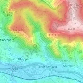
Nom : Carte topographique Gundelsbach, altitude, relief.
Altitude moyenne : 337 m
Altitude minimum : 228 m
Altitude maximum : 522 m
Faire un don
Équipez-vous pour votre prochaine aventure :
En tant que Partenaire Amazon, ce site perçoit une commission sur les achats éligibles sans surcoût pour vous.
Autres cartes topographiques
Cliquez sur une carte pour visualiser sa topographie, son altitude et son relief.
Faire un don
Équipez-vous pour votre prochaine aventure :
En tant que Partenaire Amazon, ce site perçoit une commission sur les achats éligibles sans surcoût pour vous.
Spiegelberg
Germany > Baden-Württemberg > Rems-Murr-Kreis
The municipality (Gemeinde) of Spiegelberg is located at the northern edge of the Rems-Murr district of Baden-Württemberg, along its border with the district of Heilbronn. Spiegelberg is situated in the valley of the Lauter and within the Swabian-Franconian Forest. Elevation above sea level in the municipal…
Altitude moyenne : 446 m
Faire un don
Équipez-vous pour votre prochaine aventure :
En tant que Partenaire Amazon, ce site perçoit une commission sur les achats éligibles sans surcoût pour vous.
Sulzbach an der Murr
Germany > Baden-Württemberg > Rems-Murr-Kreis
The municipality (Gemeinde) of Sulzbach an der Murr is located in the Rems-Murr district, in the German state of Baden-Württemberg. Sulzbach's municipal area is physically located in the between the Löwenstein Hills and Murrhardt Forest, regions of the greater Swabian-Franconian Forest. Elevation above sea…
Altitude moyenne : 396 m
Althütte
Germany > Baden-Württemberg > Rems-Murr-Kreis
The municipality (Gemeinde) of Althütte is located in the Rems-Murr district, in the German state of Baden-Württemberg. Althütte is physically located in the Murrhardt Forest, a region of the larger Swabian-Franconian Forest. Elevation above sea level in the municipal area ranges from a high of 571 meters…
Altitude moyenne : 464 m
Faire un don
Équipez-vous pour votre prochaine aventure :
En tant que Partenaire Amazon, ce site perçoit une commission sur les achats éligibles sans surcoût pour vous.
Backnang
Germany > Baden-Württemberg > Rems-Murr-Kreis
Before 1930 the title for this position was Stadtschultheiß. In 1930 the title became Bürgermeister (Mayor), and in 1956 with the elevation of Backnang to a "large district town," the title was changed to Oberbürgermeister (Lord Mayor).
Altitude moyenne : 302 m
Faire un don
Équipez-vous pour votre prochaine aventure :
En tant que Partenaire Amazon, ce site perçoit une commission sur les achats éligibles sans surcoût pour vous.