
Faire un don
Équipez-vous pour votre prochaine aventure :
En tant que Partenaire Amazon, ce site perçoit une commission sur les achats éligibles sans surcoût pour vous.
Carte topographique Neuhausen
Cliquez sur la carte pour afficher l’altitude.
Faire un don
Équipez-vous pour votre prochaine aventure :
En tant que Partenaire Amazon, ce site perçoit une commission sur les achats éligibles sans surcoût pour vous.
À propos de cette carte
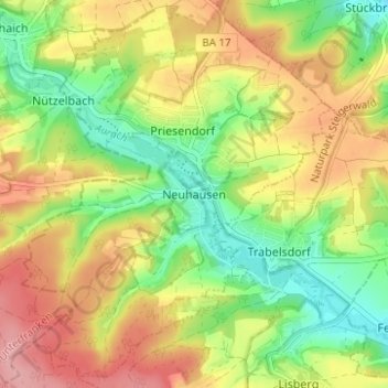
Nom : Carte topographique Neuhausen, altitude, relief.
Altitude moyenne : 331 m
Altitude minimum : 272 m
Altitude maximum : 395 m
Faire un don
Équipez-vous pour votre prochaine aventure :
En tant que Partenaire Amazon, ce site perçoit une commission sur les achats éligibles sans surcoût pour vous.
Autres cartes topographiques
Cliquez sur une carte pour visualiser sa topographie, son altitude et son relief.
Faire un don
Équipez-vous pour votre prochaine aventure :
En tant que Partenaire Amazon, ce site perçoit une commission sur les achats éligibles sans surcoût pour vous.
Litzendorf
Germany > Bavaria > Landkreis Bamberg
Litzendorf and most of its outlying centres lie in the Ellern Valley, which is surrounded by wooded heights with the Bamberg district's two highest elevations, the Geisberg (585 m) and the Stammberg (560 m).
Altitude moyenne : 362 m
Faire un don
Équipez-vous pour votre prochaine aventure :
En tant que Partenaire Amazon, ce site perçoit une commission sur les achats éligibles sans surcoût pour vous.
Faire un don
Équipez-vous pour votre prochaine aventure :
En tant que Partenaire Amazon, ce site perçoit une commission sur les achats éligibles sans surcoût pour vous.
Heiligenstadt i. OFr.
Germany > Bavaria > Landkreis Bamberg
Heiligenstadt lies in the Bamberg district’s southeastern corner. The 24 Gemeindeteile lie along the Leinleiter Valley and on the abutting Jura Plateau. Veilbronn lies 329 m above sea level. The greatest elevation is the Altenberg (mountain) behind Zoggendorf at 583 m above sea level. The villages on the…
Altitude moyenne : 468 m
Faire un don
Équipez-vous pour votre prochaine aventure :
En tant que Partenaire Amazon, ce site perçoit une commission sur les achats éligibles sans surcoût pour vous.