
Faire un don
Équipez-vous pour votre prochaine aventure :
En tant que Partenaire Amazon, ce site perçoit une commission sur les achats éligibles sans surcoût pour vous.
Carte topographique Shonto
Cliquez sur la carte pour afficher l’altitude.
Faire un don
Équipez-vous pour votre prochaine aventure :
En tant que Partenaire Amazon, ce site perçoit une commission sur les achats éligibles sans surcoût pour vous.
À propos de cette carte
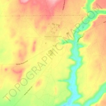
Nom : Carte topographique Shonto, altitude, relief.
Lieu : Shonto, Navajo County, Arizona, United States (36.56716 -110.69418 36.61210 -110.63624)
Altitude moyenne : 1.963 m
Altitude minimum : 1.883 m
Altitude maximum : 2.022 m
Faire un don
Équipez-vous pour votre prochaine aventure :
En tant que Partenaire Amazon, ce site perçoit une commission sur les achats éligibles sans surcoût pour vous.
Autres cartes topographiques
Cliquez sur une carte pour visualiser sa topographie, son altitude et son relief.
Show Low
United States > Arizona > Navajo County
Show Low is a city in Navajo County, Arizona. It lies on the Mogollon Rim in east central Arizona, at an elevation of 6,345 feet (1,934 m). The city was established in 1870 and incorporated in 1953. According to the 2010 census, the population of the city was 10,660.
Altitude moyenne : 1.957 m
Faire un don
Équipez-vous pour votre prochaine aventure :
En tant que Partenaire Amazon, ce site perçoit une commission sur les achats éligibles sans surcoût pour vous.
Monument Valley
United States > Arizona > Navajo County
The area is part of the Colorado Plateau. The elevation of the valley floor ranges from 5,000 to 6,000 feet (1,500 to 1,800 m) above sea level. The floor is largely siltstone of the Cutler Group, or sand derived from it, deposited by the meandering rivers that carved the valley. The valley's vivid red color…
Altitude moyenne : 1.675 m
Faire un don
Équipez-vous pour votre prochaine aventure :
En tant que Partenaire Amazon, ce site perçoit une commission sur les achats éligibles sans surcoût pour vous.
Faire un don
Équipez-vous pour votre prochaine aventure :
En tant que Partenaire Amazon, ce site perçoit une commission sur les achats éligibles sans surcoût pour vous.
Navajo National Monument
United States > Arizona > Navajo County
It is thought that these Ancestral Pueblo people lived in these cave dwellings to optimize the amount of sustainable land to produce crops. By living in these caves, and not on the mesas or the canyon floors, they were able to use this land towards agricultural production to ensure their success in this high…
Altitude moyenne : 2.096 m
Linden
United States > Arizona > Navajo County
Linden is an unincorporated community located in Navajo County, Arizona, United States, just west of the city of Show Low. It is situated atop the Mogollon Rim at an elevation of over 6,000 feet. The community was evacuated in June 2002 due to the Rodeo-Chediski fire, which eventually consumed part of Linden,…
Altitude moyenne : 1.980 m
Faire un don
Équipez-vous pour votre prochaine aventure :
En tant que Partenaire Amazon, ce site perçoit une commission sur les achats éligibles sans surcoût pour vous.
Pinetop Country Club
United States > Arizona > Navajo County > Pinetop Country Club
Altitude moyenne : 2.221 m
Faire un don
Équipez-vous pour votre prochaine aventure :
En tant que Partenaire Amazon, ce site perçoit une commission sur les achats éligibles sans surcoût pour vous.
Faire un don
Équipez-vous pour votre prochaine aventure :
En tant que Partenaire Amazon, ce site perçoit une commission sur les achats éligibles sans surcoût pour vous.
Monument Valley
United States > Arizona > Navajo County
The area is part of the Colorado Plateau. The elevation of the valley floor ranges from 5,000 to 6,000 feet (1,500 to 1,800 m) above sea level. The floor is largely siltstone of the Cutler Group, or sand derived from it, deposited by the meandering rivers that carved the valley. The valley's vivid red color…
Altitude moyenne : 1.675 m
Show Low
United States > Arizona > Navajo County
Show Low is a city in Navajo County, Arizona. It lies on the Mogollon Rim in east central Arizona, at an elevation of 6,345 feet (1,934 m). The city was established in 1870 and incorporated in 1953. According to the 2010 census, the population of the city was 10,660.
Altitude moyenne : 1.957 m
Faire un don
Équipez-vous pour votre prochaine aventure :
En tant que Partenaire Amazon, ce site perçoit une commission sur les achats éligibles sans surcoût pour vous.
Faire un don
Équipez-vous pour votre prochaine aventure :
En tant que Partenaire Amazon, ce site perçoit une commission sur les achats éligibles sans surcoût pour vous.
Faire un don
Équipez-vous pour votre prochaine aventure :
En tant que Partenaire Amazon, ce site perçoit une commission sur les achats éligibles sans surcoût pour vous.
Monument Valley
United States > Arizona > Navajo County
The area is part of the Colorado Plateau. The elevation of the valley floor ranges from 5,000 to 6,000 feet (1,500 to 1,800 m) above sea level. The floor is largely siltstone of the Cutler Group, or sand derived from it, deposited by the meandering rivers that carved the valley. The valley's vivid red color…
Altitude moyenne : 1.675 m
Faire un don
Équipez-vous pour votre prochaine aventure :
En tant que Partenaire Amazon, ce site perçoit une commission sur les achats éligibles sans surcoût pour vous.
Show Low
United States > Arizona > Navajo County
Show Low is a city in Navajo County, Arizona. It lies on the Mogollon Rim in east central Arizona, at an elevation of 6,345 feet (1,934 m). The city was established in 1870 and incorporated in 1953. According to the 2010 census, the population of the city was 10,660.
Altitude moyenne : 1.957 m
Marsh Pass
United States > Arizona > Navajo County > Tsegi
Marsh Pass, also known as La Puerta Limita, "The Border Gate", is a gap in Navajo County, Arizona. It lies at an elevation of 6,102 feet (1,860 meters) along Laguña Creek. The name of Marsh Pass is thought to come from its location along a chain of swamps and lakes in the pass, that have since been drained by…
Altitude moyenne : 1.961 m
Faire un don
Équipez-vous pour votre prochaine aventure :
En tant que Partenaire Amazon, ce site perçoit une commission sur les achats éligibles sans surcoût pour vous.
Monument Valley
United States > Arizona > Navajo County
The area is part of the Colorado Plateau. The elevation of the valley floor ranges from 5,000 to 6,000 feet (1,500 to 1,800 m) above sea level. The floor is largely siltstone of the Cutler Group, or sand derived from it, deposited by the meandering rivers that carved the valley. The valley's vivid red color…
Altitude moyenne : 1.675 m
Faire un don
Équipez-vous pour votre prochaine aventure :
En tant que Partenaire Amazon, ce site perçoit une commission sur les achats éligibles sans surcoût pour vous.