
Carte topographique Chelmsford
Carte interactive
Cliquez sur la carte pour afficher l’altitude.
À propos de cette carte
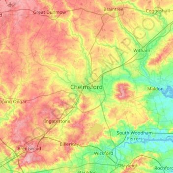
Nom : Carte topographique Chelmsford, altitude, relief.
Altitude moyenne : 53 m
Altitude minimum : -2 m
Altitude maximum : 119 m
Autres cartes topographiques
Cliquez sur une carte pour visualiser sa topographie, son altitude et son relief.
Lodge Lake
United Kingdom > England > Essex > Chelmsford
Lodge Lake, Great and Little Leighs, Chelmsford, Essex, England, United Kingdom
Altitude moyenne : 62 m