Géolocaliser

Carte topographique Ciorani

Carte interactive

Cliquez sur la carte pour afficher l’altitude.

À propos de cette carte

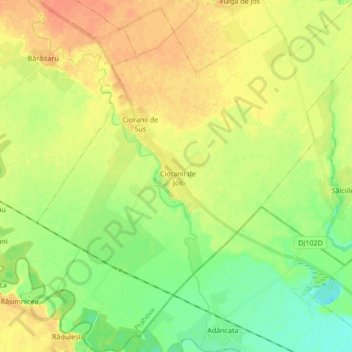
Nom : Carte topographique Ciorani, altitude, relief.

Lieu : Ciorani, Prahova, Romania (44.76105 26.34475 44.88156 26.50931)

Altitude moyenne : 75 m

Altitude minimum : 57 m

Altitude maximum : 91 m

Autres cartes topographiques

Cliquez sur une carte pour visualiser sa topographie, son altitude et son relief.

Azuga

Romania > Prahova

Azuga, Prahova, 105100, Romania

Altitude moyenne : 1.258 m

Românești

Romania > Prahova

Românești, Bărcănești, Prahova, 107058, Romania

Altitude moyenne : 116 m

Drajna

Romania > Prahova

Drajna, Prahova, Romania

Altitude moyenne : 536 m

Valea Mantei

Romania > Prahova > Valea Mantei

Valea Mantei, Valea Călugărească, Prahova, 107631, Romania

Altitude moyenne : 230 m

Valea Călugărească

Romania > Prahova > Valea Călugărească

Valea Călugărească, Prahova, Romania

Altitude moyenne : 154 m

Pușcași

Romania > Prahova > Pușcași

Pușcași, Bărcănești, Prahova, 107057, Romania

Altitude moyenne : 108 m

Sinaia

Romania > Prahova

Sinaia, Prahova, 106100, Romania

Altitude moyenne : 1.249 m

Bușteni

Romania > Prahova

Bușteni, Prahova, Romania

Altitude moyenne : 1.419 m

Plopeni

Romania > Prahova > Plopeni

Plopeni, Prahova, Romania

Altitude moyenne : 261 m

Drajna

Romania > Prahova > Slon

Drajna, Slon, Prahova, 107141, Romania

Altitude moyenne : 717 m