
Faire un don
Équipez-vous pour votre prochaine aventure :
En tant que Partenaire Amazon, ce site perçoit une commission sur les achats éligibles sans surcoût pour vous.
Carte topographique Chira
Cliquez sur la carte pour afficher l’altitude.
Faire un don
Équipez-vous pour votre prochaine aventure :
En tant que Partenaire Amazon, ce site perçoit une commission sur les achats éligibles sans surcoût pour vous.
Chira
The southern part of Qira County is mountainous with an average elevation of 3,200 m (10,500 ft) above sea level.[1] The upper reaches of the White Jade River (Yurung Kash), which provide water for Hotan (Khotan), are found in the Kunlun Mountains[1] of southern Qira County.[23] Mountain passes in the area include Mandar Kol Dawan, Shalgon Dawan, Kuchkash Bulak Dawan, and Art Dawan.[23] One of the prominent mountains in the county is Muztag[3][24] (K5,[25] Wu-lu-ko Ho Shan,[10] Mo-shih Shan,[10] Mu-shih Shan,[26] Muztagh Jilga;[23] 慕士山,[27] 木斯山[28]) which is 7,282 m (23,891 ft) above sea level.[3] The meltwater from this mountain creates the Qira River (Cele River, Ts'e-lo Ho;[10] 策勒河[29]) which flows through Qaka into the Qira county seat.[10]
Faire un don
Équipez-vous pour votre prochaine aventure :
En tant que Partenaire Amazon, ce site perçoit une commission sur les achats éligibles sans surcoût pour vous.
À propos de cette carte
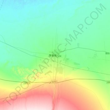
Nom : Carte topographique Chira, altitude, relief.
Lieu : Chira, Chira County, Hotan Prefecture, Xinjiang, China (36.83979 80.64153 37.15979 80.96153)
Altitude moyenne : 1.406 m
Altitude minimum : 1.313 m
Altitude maximum : 1.669 m
Faire un don
Équipez-vous pour votre prochaine aventure :
En tant que Partenaire Amazon, ce site perçoit une commission sur les achats éligibles sans surcoût pour vous.