
Carte topographique Spearfish
Carte interactive
Cliquez sur la carte pour afficher l’altitude.
À propos de cette carte
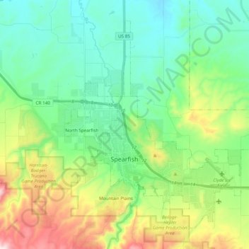
Nom : Carte topographique Spearfish, altitude, relief.
Lieu : Spearfish, Lawrence County, South Dakota, United States (44.45282 -103.90541 44.56661 -103.71413)
Altitude moyenne : 1.171 m
Altitude minimum : 984 m
Altitude maximum : 1.643 m
Extreme winter maxima in the district are remarkably warm given the latitude and altitude; on January 19, 1921 Spearfish reached a temperature of 79 °F (26 °C), the hottest January temperature in South Dakota on record.
Autres cartes topographiques
Cliquez sur une carte pour visualiser sa topographie, son altitude et son relief.
Foley Mountain
United States > South Dakota > Lawrence County
Foley Mountain, Lawrence County, South Dakota, United States
Altitude moyenne : 1.889 m
Spearfish
United States > South Dakota > Lawrence County > Spearfish
Spearfish, Lawrence County, South Dakota, 57783, United States
Altitude moyenne : 1.291 m