
Faire un don
Équipez-vous pour votre prochaine aventure :
En tant que Partenaire Amazon, ce site perçoit une commission sur les achats éligibles sans surcoût pour vous.
Carte topographique Newport County
Cliquez sur la carte pour afficher l’altitude.
Faire un don
Équipez-vous pour votre prochaine aventure :
En tant que Partenaire Amazon, ce site perçoit une commission sur les achats éligibles sans surcoût pour vous.
Newport County
The county consists of Aquidneck Island, Conanicut Island, Prudence Island, and the easternmost portion of the state on the mainland. The highest point in the county is Pocasset Hill, 320 feet (98 m) above sea level, located in Tiverton. The lowest elevation is at sea level.
Faire un don
Équipez-vous pour votre prochaine aventure :
En tant que Partenaire Amazon, ce site perçoit une commission sur les achats éligibles sans surcoût pour vous.
À propos de cette carte
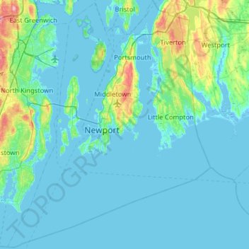
Nom : Carte topographique Newport County, altitude, relief.
Lieu : Newport County, Rhode Island, United States (41.30736 -71.50944 41.69050 -71.08857)
Altitude moyenne : 14 m
Altitude minimum : -7 m
Altitude maximum : 130 m
Faire un don
Équipez-vous pour votre prochaine aventure :
En tant que Partenaire Amazon, ce site perçoit une commission sur les achats éligibles sans surcoût pour vous.
Autres cartes topographiques
Cliquez sur une carte pour visualiser sa topographie, son altitude et son relief.
Faire un don
Équipez-vous pour votre prochaine aventure :
En tant que Partenaire Amazon, ce site perçoit une commission sur les achats éligibles sans surcoût pour vous.
Faire un don
Équipez-vous pour votre prochaine aventure :
En tant que Partenaire Amazon, ce site perçoit une commission sur les achats éligibles sans surcoût pour vous.
Diamond Hill Park
United States > Rhode Island > Providence County > Cumberland > Diamond Hill
Altitude moyenne : 83 m
Touisset Wildlife Refuge
United States > Rhode Island > Bristol County > Warren
Altitude moyenne : 6 m
Faire un don
Équipez-vous pour votre prochaine aventure :
En tant que Partenaire Amazon, ce site perçoit une commission sur les achats éligibles sans surcoût pour vous.
Faire un don
Équipez-vous pour votre prochaine aventure :
En tant que Partenaire Amazon, ce site perçoit une commission sur les achats éligibles sans surcoût pour vous.
Jerimoth Hill
United States > Rhode Island > Providence County > Foster
The hill is located on Route 101 in Foster, a half mile from the Connecticut line. To ascend the summit, for which there is a sign, there is a .3-mile (480 m) long trail that has a mere 10-foot (3.0 m) elevation gain. The hill is 812 feet (247 m) high and is located 15 miles (24 km) west of Providence, Rhode…
Altitude moyenne : 216 m
Faire un don
Équipez-vous pour votre prochaine aventure :
En tant que Partenaire Amazon, ce site perçoit une commission sur les achats éligibles sans surcoût pour vous.
Jerimoth Hill
United States > Rhode Island > Providence County > Foster
The hill is located on Route 101 in Foster, a half mile from the Connecticut line. To ascend the summit, for which there is a sign, there is a 0.3-mile (480 m) long trail that has a mere 10-foot (3.0 m) elevation gain. The hill is 812 feet (247 m) high and is located 15 miles (24 km) west of Providence, Rhode…
Altitude moyenne : 216 m
Faire un don
Équipez-vous pour votre prochaine aventure :
En tant que Partenaire Amazon, ce site perçoit une commission sur les achats éligibles sans surcoût pour vous.
Slatersville
United States > Rhode Island > Providence County > North Smithfield
Altitude moyenne : 87 m
Faire un don
Équipez-vous pour votre prochaine aventure :
En tant que Partenaire Amazon, ce site perçoit une commission sur les achats éligibles sans surcoût pour vous.
Wakefield
United States > Rhode Island > South County > South Kingstown > Wakefield
Altitude moyenne : 23 m
Faire un don
Équipez-vous pour votre prochaine aventure :
En tant que Partenaire Amazon, ce site perçoit une commission sur les achats éligibles sans surcoût pour vous.
Faire un don
Équipez-vous pour votre prochaine aventure :
En tant que Partenaire Amazon, ce site perçoit une commission sur les achats éligibles sans surcoût pour vous.
Faire un don
Équipez-vous pour votre prochaine aventure :
En tant que Partenaire Amazon, ce site perçoit une commission sur les achats éligibles sans surcoût pour vous.
Saunderstown
United States > Rhode Island > South County > North Kingstown > Saunderstown
Altitude moyenne : 14 m
Faire un don
Équipez-vous pour votre prochaine aventure :
En tant que Partenaire Amazon, ce site perçoit une commission sur les achats éligibles sans surcoût pour vous.
Olneyville
United States > Rhode Island > Providence County > Providence > Olneyville
Altitude moyenne : 24 m
Conservation Land (Trails)
United States > Rhode Island > Providence County > Cumberland
Altitude moyenne : 73 m
Faire un don
Équipez-vous pour votre prochaine aventure :
En tant que Partenaire Amazon, ce site perçoit une commission sur les achats éligibles sans surcoût pour vous.