
Carte topographique Ammanford
Carte interactive
Cliquez sur la carte pour afficher l’altitude.
À propos de cette carte
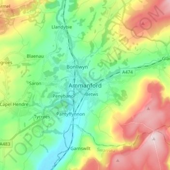
Nom : Carte topographique Ammanford, altitude, relief.
Lieu : Ammanford, Carmarthenshire, Wales, SA18 3DL, United Kingdom (51.75263 -4.02877 51.83263 -3.94877)
Altitude moyenne : 142 m
Altitude minimum : 10 m
Altitude maximum : 374 m
Autres cartes topographiques
Cliquez sur une carte pour visualiser sa topographie, son altitude et son relief.
Glanamman
United Kingdom > Wales > Carmarthenshire
Glanamman, Carmarthenshire, Wales, SA18 1DJ, United Kingdom
Altitude moyenne : 188 m
Carway
United Kingdom > Wales > Carmarthenshire
Carway, Carmarthenshire, Wales, SA17 4HL, United Kingdom
Altitude moyenne : 75 m
Birds Hill
United Kingdom > Wales > Carmarthenshire > Llandeilo
Birds Hill, Llandeilo, Carmarthenshire, Wales, SA19 6SH, United Kingdom
Altitude moyenne : 53 m