
Carte topographique Town of Stockport
Carte interactive
Cliquez sur la carte pour afficher l’altitude.
À propos de cette carte
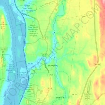
Nom : Carte topographique Town of Stockport, altitude, relief.
Lieu : Town of Stockport, Columbia County, New York, United States (42.28070 -73.78727 42.35705 -73.71919)
Altitude moyenne : 41 m
Altitude minimum : -5 m
Altitude maximum : 120 m
Autres cartes topographiques
Cliquez sur une carte pour visualiser sa topographie, son altitude et son relief.
Hamlet of Copake
United States > New York > Columbia County
Hamlet of Copake, Town of Copake, Columbia County, New York, United States
Altitude moyenne : 176 m
Nutten Hook State Tidal Wetland
United States > New York > Columbia County > Town of Stuyvesant
Nutten Hook State Tidal Wetland, Town of Stuyvesant, Columbia County, New York, United States
Altitude moyenne : 32 m
Town of Kinderhook
United States > New York > Columbia County
Town of Kinderhook, Columbia County, New York, United States
Altitude moyenne : 78 m
Craryville
United States > New York > Columbia County
Craryville, Town of Copake, Columbia County, New York, 12529, United States
Altitude moyenne : 230 m
Stuyvesant Falls
United States > New York > Columbia County > Town of Stuyvesant
Stuyvesant Falls, Town of Stuyvesant, Columbia County, New York, 12174, United States
Altitude moyenne : 58 m
Town of Gallatin
United States > New York > Columbia County
Town of Gallatin, Columbia County, New York, 12502, United States
Altitude moyenne : 186 m
Malden Bridge
United States > New York > Columbia County > Town of Chatham
Malden Bridge, Town of Chatham, Columbia County, New York, 12115, United States
Altitude moyenne : 151 m
Chatham Center
United States > New York > Columbia County > Town of Chatham
Chatham Center, Town of Chatham, Columbia County, New York, United States
Altitude moyenne : 124 m
Martindale
United States > New York > Columbia County > Town of Claverack
Martindale, Town of Claverack, Columbia County, New York, 12521, United States
Altitude moyenne : 229 m
Red Rock
United States > New York > Columbia County > Town of Canaan
Red Rock, Town of Canaan, Columbia County, New York, 12165, United States
Altitude moyenne : 331 m
Elizaville
United States > New York > Columbia County > Town of Livingston
Elizaville, Town of Livingston, Columbia County, New York, 12523, United States
Altitude moyenne : 105 m
Lebanon Springs
United States > New York > Columbia County > Town of New Lebanon
Lebanon Springs, Town of New Lebanon, Columbia County, New York, 12125, United States
Altitude moyenne : 314 m
Town of Livingston
United States > New York > Columbia County
Town of Livingston, Columbia County, New York, United States
Altitude moyenne : 109 m
Mellenville
United States > New York > Columbia County > Town of Claverack
Mellenville, Town of Claverack, Columbia County, New York, 12544, United States
Altitude moyenne : 114 m
Spencertown
United States > New York > Columbia County > Town of Austerlitz
Spencertown, Town of Austerlitz, Columbia County, New York, 12165, United States
Altitude moyenne : 279 m
New Forge
United States > New York > Columbia County > Town of Taghkanic
New Forge, Town of Taghkanic, Columbia County, New York, 12502, United States
Altitude moyenne : 193 m
Snyderville
United States > New York > Columbia County
Snyderville, Town of Gallatin, Columbia County, New York, 12523, United States
Altitude moyenne : 140 m
New Concord
United States > New York > Columbia County > Town of Chatham
New Concord, Town of Chatham, Columbia County, New York, 12060, United States
Altitude moyenne : 254 m
West Taghkanic
United States > New York > Columbia County > Town of Taghkanic
West Taghkanic, Town of Taghkanic, Columbia County, New York, United States
Altitude moyenne : 147 m
Blue Stores
United States > New York > Columbia County > Town of Livingston
Blue Stores, Town of Livingston, Columbia County, New York, 12526, United States
Altitude moyenne : 63 m
Spaulding Furnace
United States > New York > Columbia County
Spaulding Furnace, Town of Gallatin, Columbia County, New York, United States
Altitude moyenne : 174 m
Gallatinville
United States > New York > Columbia County
Gallatinville, Town of Gallatin, Columbia County, New York, 12502, United States
Altitude moyenne : 181 m
Taconic Shores
United States > New York > Columbia County
Taconic Shores, Town of Copake, Columbia County, New York, 12516, United States
Altitude moyenne : 180 m
Churchtown
United States > New York > Columbia County > Town of Claverack
Churchtown, Town of Claverack, Columbia County, New York, 12530, United States
Altitude moyenne : 119 m
Rayville
United States > New York > Columbia County > Town of Chatham
Rayville, Town of Chatham, Columbia County, New York, 12024, United States
Altitude moyenne : 240 m
Boston Corner
United States > New York > Columbia County > Town of Ancram
Boston Corner, Town of Ancram, Columbia County, New York, United States
Altitude moyenne : 316 m
Pulvers
United States > New York > Columbia County > Town of Ghent
Pulvers, Town of Ghent, Columbia County, New York, 12075, United States
Altitude moyenne : 111 m
West Lebanon
United States > New York > Columbia County > Town of New Lebanon
West Lebanon, Town of New Lebanon, Columbia County, New York, 12195, United States
Altitude moyenne : 243 m
Burden
United States > New York > Columbia County > Town of Livingston
Burden, Town of Livingston, Columbia County, New York, United States
Altitude moyenne : 60 m
Harlemville
United States > New York > Columbia County > Town of Hillsdale
Harlemville, Town of Hillsdale, Columbia County, New York, 42529, United States
Altitude moyenne : 246 m
Rogers Island
United States > New York > Columbia County
Rogers Island, Town of Greenport, Columbia County, New York, United States
Altitude moyenne : 26 m
Arnolds Mill
United States > New York > Columbia County > Town of Ghent
Arnolds Mill, Town of Ghent, Columbia County, New York, 12037, United States
Altitude moyenne : 178 m
West Copake
United States > New York > Columbia County
West Copake, Town of Copake, Columbia County, New York, 12516, United States
Altitude moyenne : 181 m
Riders
United States > New York > Columbia County > Town of Chatham
Riders, Town of Chatham, Columbia County, New York, 12024, United States
Altitude moyenne : 216 m
Canaan Center
United States > New York > Columbia County > Town of Canaan
Canaan Center, Town of Canaan, Columbia County, New York, 12029, United States
Altitude moyenne : 330 m
Newton Hook
United States > New York > Columbia County > Town of Stuyvesant
Newton Hook, Town of Stuyvesant, Columbia County, New York, 12173, United States
Altitude moyenne : 26 m
Linlithgo Mills
United States > New York > Columbia County > Town of Livingston
Linlithgo Mills, Town of Livingston, Columbia County, New York, 12541, United States
Altitude moyenne : 76 m
North Hillsdale
United States > New York > Columbia County > Town of Hillsdale
North Hillsdale, Town of Hillsdale, Columbia County, New York, United States
Altitude moyenne : 308 m
West Ghent
United States > New York > Columbia County > Town of Ghent
West Ghent, Town of Ghent, Columbia County, New York, 12174, United States
Altitude moyenne : 72 m
Silvernails
United States > New York > Columbia County
Silvernails, Town of Gallatin, Columbia County, New York, 12567, United States
Altitude moyenne : 159 m
Hollowville
United States > New York > Columbia County > Town of Claverack
Hollowville, Town of Claverack, Columbia County, New York, 12530, United States
Altitude moyenne : 135 m
Rock City
United States > New York > Columbia County > Town of Chatham
Rock City, Town of Chatham, Columbia County, New York, 12136, United States
Altitude moyenne : 205 m
Riders Mills
United States > New York > Columbia County > Town of Chatham
Riders Mills, Town of Chatham, Columbia County, New York, 12024, United States
Altitude moyenne : 174 m
Flatbrook
United States > New York > Columbia County > Town of Canaan
Flatbrook, Town of Canaan, Columbia County, New York, 12029, United States
Altitude moyenne : 357 m
Weed Mines
United States > New York > Columbia County > Town of Ancram
Weed Mines, Town of Ancram, Columbia County, New York, 12516, United States
Altitude moyenne : 211 m
Omi
United States > New York > Columbia County > Town of Ghent
Omi, Town of Ghent, Columbia County, New York, 12075, United States
Altitude moyenne : 93 m
East Taghkanic
United States > New York > Columbia County > Town of Taghkanic
East Taghkanic, Town of Taghkanic, Columbia County, New York, 12521, United States
Altitude moyenne : 200 m
New Lebanon Center
United States > New York > Columbia County > Town of New Lebanon
New Lebanon Center, Town of New Lebanon, Columbia County, New York, 12125, United States
Altitude moyenne : 284 m
New Britain
United States > New York > Columbia County > Town of New Lebanon
New Britain, Town of New Lebanon, Columbia County, New York, 12060, United States
Altitude moyenne : 311 m
Valatie Colony
United States > New York > Columbia County > Town of Kinderhook
Valatie Colony, Town of Kinderhook, Columbia County, New York, 12184, United States
Altitude moyenne : 94 m