
Carte topographique Großderschau
Carte interactive
Cliquez sur la carte pour afficher l’altitude.
À propos de cette carte
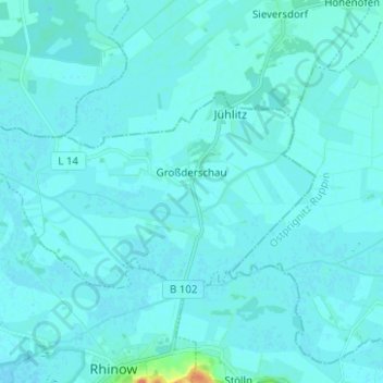
Nom : Carte topographique Großderschau, altitude, relief.
Lieu : Großderschau, Rhinow, Havelland, Brandenburg, Deutschland (52.76633 12.28200 52.80539 12.40685)
Altitude moyenne : 27 m
Altitude minimum : 24 m
Altitude maximum : 76 m
Autres cartes topographiques
Cliquez sur une carte pour visualiser sa topographie, son altitude et son relief.
Seeblick
Deutschland > Brandenburg > Havelland > Rhinow
Seeblick, Rhinow, Havelland, Brandenburg, Deutschland
Altitude moyenne : 33 m
Gollenberg
Deutschland > Brandenburg > Havelland > Rhinow
Gollenberg, Rhinow, Havelland, Brandenburg, Deutschland
Altitude moyenne : 34 m
Stölln
Deutschland > Brandenburg > Havelland > Rhinow
Stölln, Gollenberg, Rhinow, Havelland, Brandenburg, Deutschland
Altitude moyenne : 35 m
Gülpe
Deutschland > Brandenburg > Havelland > Rhinow
Gülpe, Havelaue, Rhinow, Havelland, Brandenburg, Deutschland
Altitude moyenne : 26 m