
Faire un don
Équipez-vous pour votre prochaine aventure :
En tant que Partenaire Amazon, ce site perçoit une commission sur les achats éligibles sans surcoût pour vous.
Carte topographique Shorncote
Cliquez sur la carte pour afficher l’altitude.
Faire un don
Équipez-vous pour votre prochaine aventure :
En tant que Partenaire Amazon, ce site perçoit une commission sur les achats éligibles sans surcoût pour vous.
À propos de cette carte
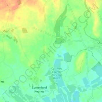
Nom : Carte topographique Shorncote, altitude, relief.
Altitude moyenne : 96 m
Altitude minimum : 82 m
Altitude maximum : 118 m
Faire un don
Équipez-vous pour votre prochaine aventure :
En tant que Partenaire Amazon, ce site perçoit une commission sur les achats éligibles sans surcoût pour vous.
Autres cartes topographiques
Cliquez sur une carte pour visualiser sa topographie, son altitude et son relief.
Upper Rissington
United Kingdom > England > Gloucestershire > Cotswold District > Upper Rissington
Altitude moyenne : 208 m
Cirencester
United Kingdom > England > Gloucestershire > Cotswold District
On Cotswold Avenue is the site of a Roman amphitheatre which, while buried, retains its shape in the earthen topography of the small park setting. Cirencester was one of the most substantial cities of Roman-era Britain.
Altitude moyenne : 128 m
Worcestershire (detached)
United Kingdom > England > Gloucestershire > Cotswold District
Altitude moyenne : 103 m
Faire un don
Équipez-vous pour votre prochaine aventure :
En tant que Partenaire Amazon, ce site perçoit une commission sur les achats éligibles sans surcoût pour vous.
Cirencester Park
United Kingdom > England > Gloucestershire > Cotswold District > Sapperton
Altitude moyenne : 162 m
Cold Aston
United Kingdom > England > Gloucestershire > Cotswold District > Cold Aston
Altitude moyenne : 189 m
South Cerney
United Kingdom > England > Gloucestershire > Cotswold District > South Cerney
Altitude moyenne : 93 m
Faire un don
Équipez-vous pour votre prochaine aventure :
En tant que Partenaire Amazon, ce site perçoit une commission sur les achats éligibles sans surcoût pour vous.
Bourton-on-the-Hill
United Kingdom > England > Gloucestershire > Cotswold District
Altitude moyenne : 200 m
Faire un don
Équipez-vous pour votre prochaine aventure :
En tant que Partenaire Amazon, ce site perçoit une commission sur les achats éligibles sans surcoût pour vous.
Little Rissington
United Kingdom > England > Gloucestershire > Cotswold District > Little Rissington
Altitude moyenne : 171 m
Coberley
United Kingdom > England > Gloucestershire > Cotswold District > Coberley
Altitude moyenne : 234 m
Faire un don
Équipez-vous pour votre prochaine aventure :
En tant que Partenaire Amazon, ce site perçoit une commission sur les achats éligibles sans surcoût pour vous.
Chipping Campden
United Kingdom > England > Gloucestershire > Cotswold District
Altitude moyenne : 191 m
Bibury
United Kingdom > England > Gloucestershire > Cotswold District
The parish is approximately rectangular and stretches far to the rolling, elevated, north. It includes on outlying settlement, Ablington, in the upper valley. Bibury Farm is 300 metres (330 yd) from the village, 151 metres (495 ft) above Ordnance Datum (AOD), which is a similar elevation to much of the north.…
Altitude moyenne : 135 m
Botany Bay Wood
United Kingdom > England > Gloucestershire > Cotswold District > Stow-on-the-Wold
Altitude moyenne : 171 m
Faire un don
Équipez-vous pour votre prochaine aventure :
En tant que Partenaire Amazon, ce site perçoit une commission sur les achats éligibles sans surcoût pour vous.
Baunton
United Kingdom > England > Gloucestershire > Cotswold District > Baunton
Altitude moyenne : 146 m
Somerford Keynes
United Kingdom > England > Gloucestershire > Cotswold District > Somerford Keynes
Altitude moyenne : 92 m
Faire un don
Équipez-vous pour votre prochaine aventure :
En tant que Partenaire Amazon, ce site perçoit une commission sur les achats éligibles sans surcoût pour vous.
Evenlode
United Kingdom > England > Gloucestershire > Cotswold District > Evenlode
Altitude moyenne : 134 m
Great Rissington
United Kingdom > England > Gloucestershire > Cotswold District > Great Rissington
Altitude moyenne : 168 m
Long Newnton
United Kingdom > England > Gloucestershire > Cotswold District > Long Newnton
Altitude moyenne : 117 m
Faire un don
Équipez-vous pour votre prochaine aventure :
En tant que Partenaire Amazon, ce site perçoit une commission sur les achats éligibles sans surcoût pour vous.
Bagendon
United Kingdom > England > Gloucestershire > Cotswold District > Bagendon
Altitude moyenne : 171 m
Didmarton
United Kingdom > England > Gloucestershire > Cotswold District > Didmarton
Altitude moyenne : 147 m
Faire un don
Équipez-vous pour votre prochaine aventure :
En tant que Partenaire Amazon, ce site perçoit une commission sur les achats éligibles sans surcoût pour vous.
Daglingworth
United Kingdom > England > Gloucestershire > Cotswold District > Daglingworth
Altitude moyenne : 169 m
Faire un don
Équipez-vous pour votre prochaine aventure :
En tant que Partenaire Amazon, ce site perçoit une commission sur les achats éligibles sans surcoût pour vous.
Poulton
United Kingdom > England > Gloucestershire > Cotswold District > Poulton
Altitude moyenne : 109 m
Bourton-on-the-Water
United Kingdom > England > Gloucestershire > Cotswold District
Altitude moyenne : 155 m
Winson
United Kingdom > England > Gloucestershire > Cotswold District > Winson
Altitude moyenne : 145 m
Faire un don
Équipez-vous pour votre prochaine aventure :
En tant que Partenaire Amazon, ce site perçoit une commission sur les achats éligibles sans surcoût pour vous.
Windrush
United Kingdom > England > Gloucestershire > Cotswold District > Windrush
Altitude moyenne : 155 m
Sherborne
United Kingdom > England > Gloucestershire > Cotswold District > Sherborne
Altitude moyenne : 156 m
Faire un don
Équipez-vous pour votre prochaine aventure :
En tant que Partenaire Amazon, ce site perçoit une commission sur les achats éligibles sans surcoût pour vous.
Elkstone
United Kingdom > England > Gloucestershire > Cotswold District > Elkstone
Altitude moyenne : 234 m
Down Ampney
United Kingdom > England > Gloucestershire > Cotswold District > Down Ampney
Altitude moyenne : 85 m
Hazleton
United Kingdom > England > Gloucestershire > Cotswold District > Hazleton
Altitude moyenne : 227 m
Faire un don
Équipez-vous pour votre prochaine aventure :
En tant que Partenaire Amazon, ce site perçoit une commission sur les achats éligibles sans surcoût pour vous.
Chedworth
United Kingdom > England > Gloucestershire > Cotswold District > Chedworth
Altitude moyenne : 187 m
Faire un don
Équipez-vous pour votre prochaine aventure :
En tant que Partenaire Amazon, ce site perçoit une commission sur les achats éligibles sans surcoût pour vous.
Bushley Muzzard, Brimpsfield
United Kingdom > England > Gloucestershire > Cotswold District > Nettleton > Watercombe
Altitude moyenne : 261 m
Fairford
United Kingdom > England > Gloucestershire > Cotswold District > Fairford
Altitude moyenne : 98 m
Faire un don
Équipez-vous pour votre prochaine aventure :
En tant que Partenaire Amazon, ce site perçoit une commission sur les achats éligibles sans surcoût pour vous.
Moreton-in-Marsh
United Kingdom > England > Gloucestershire > Cotswold District
Altitude moyenne : 135 m
Knap House Quarry, Birdlip
United Kingdom > England > Gloucestershire > Cotswold District > Birdlip
Altitude moyenne : 222 m
Faire un don
Équipez-vous pour votre prochaine aventure :
En tant que Partenaire Amazon, ce site perçoit une commission sur les achats éligibles sans surcoût pour vous.
Temple Guiting
United Kingdom > England > Gloucestershire > Cotswold District
Altitude moyenne : 226 m
Cirencester
United Kingdom > England > Gloucestershire > Cotswold District
On Cotswold Avenue is the site of a Roman amphitheatre which, while buried, retains its shape in the earthen topography of the small park setting. Cirencester was one of the most substantial cities of Roman-era Britain.
Altitude moyenne : 128 m
Faire un don
Équipez-vous pour votre prochaine aventure :
En tant que Partenaire Amazon, ce site perçoit une commission sur les achats éligibles sans surcoût pour vous.
Didmarton
United Kingdom > England > Gloucestershire > Cotswold District > Didmarton
Altitude moyenne : 147 m
Faire un don
Équipez-vous pour votre prochaine aventure :
En tant que Partenaire Amazon, ce site perçoit une commission sur les achats éligibles sans surcoût pour vous.
Cirencester
United Kingdom > England > Gloucestershire > Cotswold District > Chesterton
On Cotswold Avenue is the site of a Roman amphitheatre which, while buried, retains its shape in the earthen topography of the small park setting. Cirencester was one of the most substantial cities of Roman-era Britain.
Altitude moyenne : 128 m
Chipping Campden
United Kingdom > England > Gloucestershire > Cotswold District
Altitude moyenne : 191 m
Cirencester
United Kingdom > England > Gloucestershire > Cotswold District > Chesterton
On Cotswold Avenue is the site of a Roman amphitheatre which, while buried, retains its shape in the earthen topography of the small park setting. Cirencester was one of the most substantial cities of Roman-era Britain.
Altitude moyenne : 128 m
Faire un don
Équipez-vous pour votre prochaine aventure :
En tant que Partenaire Amazon, ce site perçoit une commission sur les achats éligibles sans surcoût pour vous.
Cirencester
United Kingdom > England > Gloucestershire > Cotswold District > Chesterton
On Cotswold Avenue is the site of a Roman amphitheatre which, while buried, retains its shape in the earthen topography of the small park setting. Cirencester was one of the most substantial cities of Roman-era Britain.
Altitude moyenne : 128 m