
Carte topographique East Lothian
Carte interactive
Cliquez sur la carte pour afficher l’altitude.
À propos de cette carte
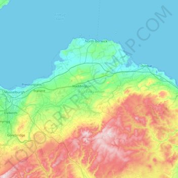
Nom : Carte topographique East Lothian, altitude, relief.
Lieu : East Lothian, Scotland, United Kingdom (55.81732 -3.08928 56.07929 -2.36328)
Altitude moyenne : 132 m
Altitude minimum : -7 m
Altitude maximum : 531 m
Autres cartes topographiques
Cliquez sur une carte pour visualiser sa topographie, son altitude et son relief.
North Berwick
United Kingdom > Scotland > East Lothian
North Berwick, East Lothian, Scotland, EH39 4HE, United Kingdom
Altitude moyenne : 21 m
Dunbar
United Kingdom > Scotland > East Lothian
Dunbar, East Lothian, Scotland, EH42 1ER, United Kingdom
Altitude moyenne : 24 m