
Carte topographique Town of Lee
Carte interactive
Cliquez sur la carte pour afficher l’altitude.
À propos de cette carte
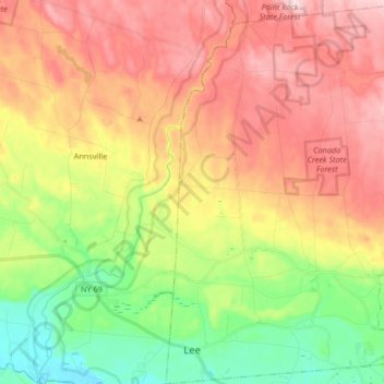
Nom : Carte topographique Town of Lee, altitude, relief.
Lieu : Town of Lee, Oneida County, New York, 13363, United States (43.26801 -75.58324 43.38868 -75.45123)
Altitude moyenne : 247 m
Altitude minimum : 116 m
Altitude maximum : 379 m
Autres cartes topographiques
Cliquez sur une carte pour visualiser sa topographie, son altitude et son relief.
Town of Sangerfield
United States > New York > Oneida County
Town of Sangerfield, Oneida County, New York, United States
Altitude moyenne : 436 m
Brothertown
United States > New York > Oneida County > Town of Marshall
Brothertown, Town of Marshall, Oneida County, New York, 13328, United States
Altitude moyenne : 340 m
Town of Remsen
United States > New York > Oneida County
Town of Remsen, Oneida County, New York, United States
Altitude moyenne : 391 m
Village of Oriskany
United States > New York > Oneida County
Village of Oriskany, Town of Whitestown, Oneida County, New York, United States
Altitude moyenne : 145 m
Town of New Hartford
United States > New York > Oneida County
Town of New Hartford, Oneida County, New York, United States
Altitude moyenne : 240 m
Verona Beach
United States > New York > Oneida County > Town of Verona
Verona Beach, Town of Verona, Oneida County, New York, 13162, United States
Altitude moyenne : 114 m
Sauquoit
United States > New York > Oneida County > Town of Paris
Sauquoit, Town of Paris, Oneida County, New York, 13456, United States
Altitude moyenne : 309 m
Village of New York Mills
United States > New York > Oneida County
Village of New York Mills, Town of Whitestown, Oneida County, New York, 13417, United States
Altitude moyenne : 154 m
Town of Boonville
United States > New York > Oneida County
Town of Boonville, Oneida County, New York, 13309, United States
Altitude moyenne : 394 m
Town of Camden
United States > New York > Oneida County
Town of Camden, Oneida County, New York, 13316, United States
Altitude moyenne : 214 m
Village of Clayville
United States > New York > Oneida County
Village of Clayville, Town of Paris, Oneida County, New York, United States
Altitude moyenne : 361 m
Otter Lake
United States > New York > Oneida County > Town of Forestport
Otter Lake, Town of Forestport, Oneida County, New York, United States
Altitude moyenne : 494 m
Town of Annsville
United States > New York > Oneida County
Town of Annsville, Oneida County, New York, 13471, United States
Altitude moyenne : 273 m
Brookfield
United States > New York > Oneida County > Town of Lee
Brookfield, Town of Lee, Oneida County, New York, 13471, United States
Altitude moyenne : 201 m
Town of Marcy
United States > New York > Oneida County
Town of Marcy, Whitestown, Oneida County, New York, United States
Altitude moyenne : 207 m
Village of Camden
United States > New York > Oneida County
Village of Camden, Town of Camden, Oneida County, New York, United States
Altitude moyenne : 168 m
Town of Kirkland
United States > New York > Oneida County
Town of Kirkland, Oneida County, New York, United States
Altitude moyenne : 258 m
Town of Trenton
United States > New York > Oneida County
Town of Trenton, Oneida County, New York, United States
Altitude moyenne : 277 m
Washington Mills
United States > New York > Oneida County
Washington Mills, Town of New Hartford, Oneida County, New York, United States
Altitude moyenne : 235 m
White Lake
United States > New York > Oneida County > Town of Forestport
White Lake, Town of Forestport, Oneida County, New York, 13494, United States
Altitude moyenne : 453 m
City of Rome
United States > New York > Oneida County
City of Rome, Oneida County, New York, United States
Altitude moyenne : 190 m
Western
United States > New York > Oneida County
Western, Oneida County, New York, 13486, United States
Altitude moyenne : 307 m
Town of Forestport
United States > New York > Oneida County
Town of Forestport, Oneida County, New York, United States
Altitude moyenne : 404 m
Village of Clinton
United States > New York > Oneida County > Town of Kirkland
Village of Clinton, Town of Kirkland, Oneida County, New York, United States
Altitude moyenne : 191 m
Cassville
United States > New York > Oneida County > Town of Paris > Cassville
Cassville, Town of Paris, Oneida County, New York, 13318, United States
Altitude moyenne : 414 m
Blossvale
United States > New York > Oneida County > Town of Annsville > Blossvale
Blossvale, Town of Annsville, Oneida County, New York, 13401, United States
Altitude moyenne : 147 m
Ridge Mills
United States > New York > Oneida County > City of Rome > Ridge Mills
Ridge Mills, City of Rome, Oneida County, New York, 13440, United States
Altitude moyenne : 152 m
Town of Deerfield
United States > New York > Oneida County
Town of Deerfield, Oneida County, New York, United States
Altitude moyenne : 286 m
City of Utica
United States > New York > Oneida County
City of Utica, Oneida County, New York, United States
Altitude moyenne : 183 m
Town of Steuben
United States > New York > Oneida County
Town of Steuben, Oneida County, New York, United States
Altitude moyenne : 373 m
Westdale
United States > New York > Oneida County > Westdale
Westdale, Town of Camden, Oneida County, New York, 13483, United States
Altitude moyenne : 191 m
Stittville
United States > New York > Oneida County > Stittville
Stittville, Town of Marcy, Oneida County, New York, 13469, United States
Altitude moyenne : 182 m
White Lake
United States > New York > Oneida County
White Lake, Town of Forestport, Oneida County, New York, United States
Altitude moyenne : 448 m
Rome
United States > New York > Oneida County > City of Rome > Rome
Rome, City of Rome, Oneida County, New York, 13440-5621, United States
Altitude moyenne : 143 m