
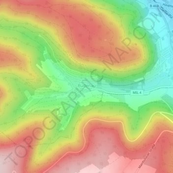
Carte topographique Rüdenau
Carte interactive
Cliquez sur la carte pour afficher l’altitude.
À propos de cette carte
Nom : Carte topographique Rüdenau, altitude, relief.
Altitude moyenne : 301 m
Altitude minimum : 126 m
Altitude maximum : 453 m
Rüdenau liegt in der Region Bayerischer Untermain. Der topographisch höchste Punkt der Gemeindegemarkung befindet sich mit 410 m ü. NHN am Osthang des Berges „Rauschen“, westlich von Rüdenau, der niedrigste liegt am Rüdenauer Bach auf 163 m ü. NHN.
Autres cartes topographiques
Cliquez sur une carte pour visualiser sa topographie, son altitude et son relief.
Neunkirchen
Deutschland > Bayern > Landkreis Miltenberg
Neunkirchen, Verwaltungsgemeinschaft Erftal, Landkreis Miltenberg, Bayern, 63930, Deutschland
Altitude moyenne : 332 m
63843
Deutschland > Bayern > Landkreis Miltenberg > Niedernberg
63843, Niedernberg, Landkreis Miltenberg, Bayern, Deutschland
Altitude moyenne : 124 m
Dorfprozelten
Deutschland > Bayern > Landkreis Miltenberg
Dorfprozelten, Landkreis Miltenberg, Bayern, 97904, Deutschland
Altitude moyenne : 274 m
Kirschfurt
Deutschland > Bayern > Landkreis Miltenberg
Kirschfurt, Collenberg, Landkreis Miltenberg, Bayern, 97896, Deutschland
Altitude moyenne : 276 m
Bürgstadt
Deutschland > Bayern > Landkreis Miltenberg
Bürgstadt, Verwaltungsgemeinschaft Erftal, Landkreis Miltenberg, Bayern, 63927, Deutschland
Altitude moyenne : 237 m
Weilbach
Deutschland > Bayern > Landkreis Miltenberg
Weilbach, Landkreis Miltenberg, Bayern, 63937, Deutschland
Altitude moyenne : 312 m
Altenbuch
Deutschland > Bayern > Landkreis Miltenberg
Altenbuch, Verwaltungsgemeinschaft Stadtprozelten, Landkreis Miltenberg, Bayern, 97901, Deutschland
Altitude moyenne : 386 m
Sommerau
Deutschland > Bayern > Landkreis Miltenberg
Sommerau, Eschau, Landkreis Miltenberg, Bayern, 63863, Deutschland
Altitude moyenne : 238 m
Miltenberg
Deutschland > Bayern > Landkreis Miltenberg
Miltenberg, Landkreis Miltenberg, Bayern, 63897, Deutschland
Altitude moyenne : 310 m
Auf der Höhe
Deutschland > Bayern > Landkreis Miltenberg > Kirchzell
Auf der Höhe, Kirchzell, Landkreis Miltenberg, Bayern, 64754, Deutschland
Altitude moyenne : 490 m
Watterbach
Deutschland > Bayern > Landkreis Miltenberg > Kirchzell
Watterbach, Kirchzell, Landkreis Miltenberg, Bayern, Deutschland
Altitude moyenne : 432 m
Soden
Deutschland > Bayern > Landkreis Miltenberg
Soden, Sulzbach am Main, Landkreis Miltenberg, Bayern, 63834, Deutschland
Altitude moyenne : 241 m
Klingenberg
Deutschland > Bayern > Landkreis Miltenberg > Klingenberg am Main
Klingenberg, Klingenberg am Main, Landkreis Miltenberg, Bayern, Deutschland
Altitude moyenne : 230 m
Schneeberg
Deutschland > Bayern > Landkreis Miltenberg > Schneeberg
Schneeberg, Landkreis Miltenberg, Bayern, 63936, Deutschland
Altitude moyenne : 350 m
Obernburg am Main
Deutschland > Bayern > Landkreis Miltenberg
Obernburg am Main, Landkreis Miltenberg, Bayern, 63785, Deutschland
Altitude moyenne : 188 m
Großheubach
Deutschland > Bayern > Landkreis Miltenberg
Großheubach, Landkreis Miltenberg, Bayern, 63920, Deutschland
Altitude moyenne : 220 m
Heppdiel
Deutschland > Bayern > Landkreis Miltenberg
Heppdiel, Eichenbühl, Landkreis Miltenberg, Bayern, 63930, Deutschland
Altitude moyenne : 320 m
Klingenberg am Main
Deutschland > Bayern > Landkreis Miltenberg > Klingenberg am Main > Klingenberg am Main
Klingenberg am Main, Landkreis Miltenberg, Bayern, 63911, Deutschland
Altitude moyenne : 224 m
Erlenbach am Main
Deutschland > Bayern > Landkreis Miltenberg
Erlenbach am Main, Landkreis Miltenberg, Bayern, 63906, Deutschland
Altitude moyenne : 183 m
Faulbach
Deutschland > Bayern > Landkreis Miltenberg > Faulbach
Faulbach, Landkreis Miltenberg, Bayern, 97906, Deutschland
Altitude moyenne : 246 m
Großwallstadt
Deutschland > Bayern > Landkreis Miltenberg
Großwallstadt, Landkreis Miltenberg, Bayern, 63868, Deutschland
Altitude moyenne : 157 m
Kirchzell
Deutschland > Bayern > Landkreis Miltenberg > Kirchzell
Kirchzell, Landkreis Miltenberg, Bayern, 63931, Deutschland
Altitude moyenne : 363 m
Amorbach
Deutschland > Bayern > Landkreis Miltenberg
Amorbach, Landkreis Miltenberg, Bayern, 63916, Deutschland
Altitude moyenne : 353 m
Wörth am Main
Deutschland > Bayern > Landkreis Miltenberg > Wörth am Main > Wörth am Main
Wörth am Main, Landkreis Miltenberg, Bayern, 63939, Deutschland
Altitude moyenne : 216 m
Stadtprozelten
Deutschland > Bayern > Landkreis Miltenberg
Stadtprozelten, Verwaltungsgemeinschaft Stadtprozelten, Landkreis Miltenberg, Bayern, 97909, Deutschland
Altitude moyenne : 271 m
Mömlingen
Deutschland > Bayern > Landkreis Miltenberg
Mömlingen, Landkreis Miltenberg, Bayern, 63853, Deutschland
Altitude moyenne : 214 m
Röllbach
Deutschland > Bayern > Landkreis Miltenberg
Röllbach, Verwaltungsgemeinschaft Mönchberg, Landkreis Miltenberg, Bayern, 63934, Deutschland
Altitude moyenne : 278 m
Mönchberg
Deutschland > Bayern > Landkreis Miltenberg
Mönchberg, Verwaltungsgemeinschaft Mönchberg, Landkreis Miltenberg, Bayern, 63933, Deutschland
Altitude moyenne : 289 m
Amorbach
Deutschland > Bayern > Landkreis Miltenberg > Amorbach > Amorbach
Amorbach, Landkreis Miltenberg, Bayern, 63916, Deutschland
Altitude moyenne : 326 m
Buch
Deutschland > Bayern > Landkreis Miltenberg > Buch
Buch, Kirchzell, Landkreis Miltenberg, Bayern, 63931, Deutschland
Altitude moyenne : 340 m
Wenschdorf
Deutschland > Bayern > Landkreis Miltenberg > Miltenberg
Wenschdorf, Miltenberg, Landkreis Miltenberg, Bayern, 63897, Deutschland
Altitude moyenne : 408 m
Rück
Deutschland > Bayern > Landkreis Miltenberg > Elsenfeld > Rück
Rück, Elsenfeld, Landkreis Miltenberg, Bayern, 63820, Deutschland
Altitude moyenne : 231 m
Klingenberg am Main
Deutschland > Bayern > Landkreis Miltenberg
Klingenberg am Main, Landkreis Miltenberg, Bayern, 63911, Deutschland
Altitude moyenne : 226 m
Collenberg
Deutschland > Bayern > Landkreis Miltenberg
Collenberg, Landkreis Miltenberg, Bayern, 97903, Deutschland
Altitude moyenne : 305 m
Eichenbühl
Deutschland > Bayern > Landkreis Miltenberg
Eichenbühl, Landkreis Miltenberg, Bayern, 63928, Deutschland
Altitude moyenne : 336 m
Richelbach
Deutschland > Bayern > Landkreis Miltenberg > Neunkirchen
Richelbach, Neunkirchen, Verwaltungsgemeinschaft Erftal, Landkreis Miltenberg, Bayern, 63930, Deutschland
Altitude moyenne : 315 m
Sulzbach am Main
Deutschland > Bayern > Landkreis Miltenberg
Sulzbach am Main, Landkreis Miltenberg, Bayern, 63834, Deutschland
Altitude moyenne : 167 m
Leidersbach
Deutschland > Bayern > Landkreis Miltenberg
Leidersbach, Landkreis Miltenberg, Bayern, 63849, Deutschland
Altitude moyenne : 270 m
Wörth am Main
Deutschland > Bayern > Landkreis Miltenberg
Wörth am Main, Landkreis Miltenberg, Bayern, 63939, Deutschland
Altitude moyenne : 211 m
Elsenfeld
Deutschland > Bayern > Landkreis Miltenberg
Elsenfeld, Landkreis Miltenberg, Bayern, 63820, Deutschland
Altitude moyenne : 191 m
Kleinwallstadt
Deutschland > Bayern > Landkreis Miltenberg
Kleinwallstadt, Verwaltungsgemeinschaft Kleinwallstadt, Landkreis Miltenberg, Bayern, 63839, Deutschland
Altitude moyenne : 179 m