Géolocaliser

Carte topographique Nottingham Canal

Cliquez sur la carte pour afficher l’altitude.

À propos de cette carte

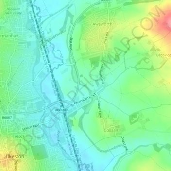
Nom : Carte topographique Nottingham Canal, altitude, relief.

Lieu : Nottingham Canal, Cossall Marsh, Broxtowe, Nottinghamshire, England, NG16 2RU, United Kingdom (52.98218 -1.28875 52.98250 -1.28855)

Altitude moyenne : 68 m

Altitude minimum : 43 m

Altitude maximum : 127 m

Autres cartes topographiques

Cliquez sur une carte pour visualiser sa topographie, son altitude et son relief.

Eastwood

United Kingdom > England > Nottinghamshire > Broxtowe > Newthorpe

Altitude moyenne : 81 m

Beeston

United Kingdom > England > Nottinghamshire > Broxtowe

Altitude moyenne : 39 m

Trowell

United Kingdom > England > Nottinghamshire > Broxtowe

Altitude moyenne : 62 m

Kimberley

United Kingdom > England > Nottinghamshire > Broxtowe

Altitude moyenne : 104 m

Beeston

United Kingdom > England > Nottinghamshire > Broxtowe

Altitude moyenne : 44 m

Brinsley

United Kingdom > England > Nottinghamshire > Broxtowe

Altitude moyenne : 100 m

Bramcote

United Kingdom > England > Nottinghamshire > Broxtowe

Altitude moyenne : 55 m

Greasley

United Kingdom > England > Nottinghamshire > Broxtowe

Altitude moyenne : 104 m

Stapleford

United Kingdom > England > Nottinghamshire > Broxtowe

Altitude moyenne : 54 m

River Erewash

United Kingdom > England > Nottinghamshire > Broxtowe

The approximate meaning of the name is not in doubt, but there is room for debate about the precise derivation and its connotations. Brewer gives the commonly accepted explanation that it comes from the Old English words irre ("wandering") and wisce ("wet meadow"). This is accepted by Kenneth Cameron, a…

Altitude moyenne : 87 m

Strelley

United Kingdom > England > Nottinghamshire > Broxtowe > Strelley

Altitude moyenne : 100 m

Nuthall

United Kingdom > England > Nottinghamshire > Broxtowe

Altitude moyenne : 95 m

Moorgreen

United Kingdom > England > Nottinghamshire > Broxtowe

Altitude moyenne : 105 m

Cossall

United Kingdom > England > Nottinghamshire > Broxtowe

Altitude moyenne : 70 m

Eastwood

United Kingdom > England > Nottinghamshire > Broxtowe

Altitude moyenne : 81 m

Eastwood

United Kingdom > England > Nottinghamshire > Broxtowe

Altitude moyenne : 81 m

Équipez-vous pour votre prochaine aventure :

💧Poches à eau - Systèmes d'hydratation pour sacs à dos
🪢Bâtons de randonnée - Bâtons télescopiques pour plus de stabilité
🧳Sacs de voyage outdoor - Sacs résistants pour aventures nature
🪜Hamacs de camping - Repos léger en pleine nature
🛰️GPS Garmin randonnée - GPS Garmin reconnus pour la randonnée et le trekking

En tant que Partenaire Amazon, ce site perçoit une commission sur les achats éligibles sans surcoût pour vous.