
Faire un don
Équipez-vous pour votre prochaine aventure :
En tant que Partenaire Amazon, ce site perçoit une commission sur les achats éligibles sans surcoût pour vous.
Carte topographique Kamenz - Kamjenc
Cliquez sur la carte pour afficher l’altitude.
Faire un don
Équipez-vous pour votre prochaine aventure :
En tant que Partenaire Amazon, ce site perçoit une commission sur les achats éligibles sans surcoût pour vous.
Kamenz - Kamjenc
This small town is located in the west of the Upper Lusatia historic region (West Lusatia), about 40 km (25 mi) northeast of Dresden and about 30 km (19 mi) northwest of Bautzen. Situated on the Black Elster river, between the West Lusatian Hills and the Lusatian Highlands rising in the south, the town was built on greywacke and granite rocks which were mined here for centuries. Kamenz railway station is the terminus of Lübbenau–Kamenz and Kamenz–Pirna railway lines. It is served by Regionalbahn trains from Dresden Hauptbahnhof, operated by the Städtebahn Sachsen. The Hutberg hill west of the town centre, at an elevation of 293 m (961 ft), is the site of an extended landscape park laid out in 1893. It is known for its major rhododendron and azalea collections flowering at Pentecost. In 1864 the Lessing Tower was erected on the hilltop, offering a panoramic view over the West Lusatian lands and the Upper Lusatian Heath and Pond Landscape in the north. About 32% of the nature in former Kamenz District is under protection, including a network of routes for riding by bicycle and hiking.
Faire un don
Équipez-vous pour votre prochaine aventure :
En tant que Partenaire Amazon, ce site perçoit une commission sur les achats éligibles sans surcoût pour vous.
À propos de cette carte
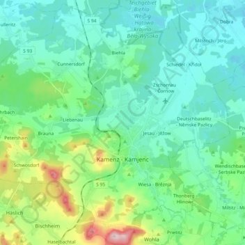
Nom : Carte topographique Kamenz - Kamjenc, altitude, relief.
Lieu : Kamenz - Kamjenc, Bautzen, Saxony, Germany (51.23001 13.99381 51.34336 14.17437)
Altitude moyenne : 186 m
Altitude minimum : 134 m
Altitude maximum : 382 m
Faire un don
Équipez-vous pour votre prochaine aventure :
En tant que Partenaire Amazon, ce site perçoit une commission sur les achats éligibles sans surcoût pour vous.
Autres cartes topographiques
Cliquez sur une carte pour visualiser sa topographie, son altitude et son relief.
Koselbruch - Kózło
Germany > Saxony > Bautzen > Hoyerswerda - Wojerecy > Schwarzkollm - Čorny Chołmc
Altitude moyenne : 133 m