
Carte topographique Valley of Flowers National Park
Carte interactive
Cliquez sur la carte pour afficher l’altitude.
À propos de cette carte
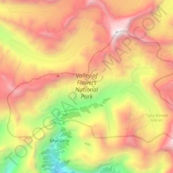
Nom : Carte topographique Valley of Flowers National Park, altitude, relief.
Altitude moyenne : 4.606 m
Altitude minimum : 2.659 m
Altitude maximum : 6.410 m
Autres cartes topographiques
Cliquez sur une carte pour visualiser sa topographie, son altitude et son relief.
Dadon
India > Uttarakhand > Joshimath Tehsil > Joshimath
Dadon, Joshimath, Joshimath Tehsil, Chamoli district, Uttarakhand, India
Altitude moyenne : 2.107 m
Pangarchulla
India > Uttarakhand > Joshimath Tehsil
Pangarchulla, Joshimath Tehsil, Chamoli District, Uttarakhand, 246483, India
Altitude moyenne : 4.061 m
Joshimath
India > Uttarakhand > Joshimath Tehsil
Joshimath, Joshimath Tehsil, Chamoli district, Uttarakhand, India
Altitude moyenne : 2.272 m
Nanda Devi
India > Uttarakhand > Joshimath Tehsil
Nanda Devi, Joshimath Tehsil, Chamoli District, Uttarakhand, India
Altitude moyenne : 6.567 m
Pinola
India > Uttarakhand > Joshimath Tehsil > Govindghat > Pinola
Pinola, Govindghat, Joshimath Tehsil, Chamoli district, Uttarakhand, India
Altitude moyenne : 2.454 m
Hemkund
India > Uttarakhand > Joshimath Tehsil
Hemkund, Joshimath Tehsil, Chamoli District, Uttarakhand, India
Altitude moyenne : 4.367 m
Badrinath
India > Uttarakhand > Joshimath Tehsil
Badrinath, Joshimath Tehsil, Chamoli District, Uttarakhand, India
Altitude moyenne : 4.052 m