
Carte topographique Bürgenstock
Carte interactive
Cliquez sur la carte pour afficher l’altitude.
À propos de cette carte
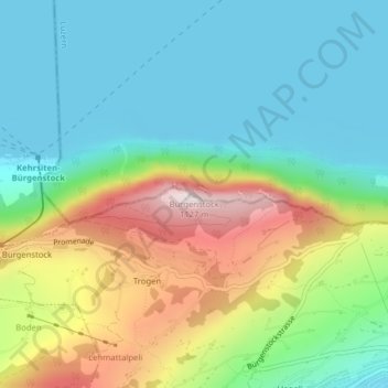
Nom : Carte topographique Bürgenstock, altitude, relief.
Lieu : Bürgenstock, Ennetbürgen, Nidwalden, 6373, Switzerland (47.00026 8.39828 47.00036 8.39838)
Altitude moyenne : 641 m
Altitude minimum : 431 m
Altitude maximum : 1.096 m
On the Dufourkarte (Dufour Map), the topographic map of Switzerland from 1844 to 1864, the mountain ridge as a whole had no name. The highest crest was referred to as Hametschwand.