
Faire un don
Équipez-vous pour votre prochaine aventure :
En tant que Partenaire Amazon, ce site perçoit une commission sur les achats éligibles sans surcoût pour vous.
Carte topographique Ludlow
Cliquez sur la carte pour afficher l’altitude.
Faire un don
Équipez-vous pour votre prochaine aventure :
En tant que Partenaire Amazon, ce site perçoit une commission sur les achats éligibles sans surcoût pour vous.
Ludlow
During the 12th century, the planned town of Ludlow was formed, in stages, the town providing a useful source of income for successive Marcher Lords, based on rents, fines, and tolls. They developed the town on a regular grid pattern, although this was adapted somewhat to match the local topography, from the late 11th century through the 12th century. The first laid street was along the ridge of the hilltop, what is now Castle Square, High Street and King Street. This formed a wide market place (later in-filled by buildings in places) running from the castle gates east across to St Laurence's and the Bull Ring, itself located on the ancient north–south road, now called Corve Street to the north and Old Street to the south. The wide Mill and Broad Streets were added later, as part of a southern grid plan of streets and burgage plots filling the area bounded by Dinham, the new High Street market, Old Street and the Teme to the south. Originally, Old Street ran down to a ford which took the ancient route south across to Ludford. A bridge was constructed (possibly by Josce de Dinan) at the foot of Broad Street, upstream of the ford, which then replaced the ford; its 15th-century replacement is the present-day Ludford Bridge.
Faire un don
Équipez-vous pour votre prochaine aventure :
En tant que Partenaire Amazon, ce site perçoit une commission sur les achats éligibles sans surcoût pour vous.
À propos de cette carte
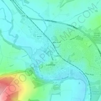
Nom : Carte topographique Ludlow, altitude, relief.
Lieu : Ludlow, Shropshire, England, United Kingdom (52.36254 -2.74025 52.38117 -2.69417)
Altitude moyenne : 108 m
Altitude minimum : 72 m
Altitude maximum : 254 m
Faire un don
Équipez-vous pour votre prochaine aventure :
En tant que Partenaire Amazon, ce site perçoit une commission sur les achats éligibles sans surcoût pour vous.
Autres cartes topographiques
Cliquez sur une carte pour visualiser sa topographie, son altitude et son relief.
Faire un don
Équipez-vous pour votre prochaine aventure :
En tant que Partenaire Amazon, ce site perçoit une commission sur les achats éligibles sans surcoût pour vous.