Géolocaliser
👉 Easily get elevation data in JSON, GeoTIFF and KML formats using Elevation API
Merci de soutenir ce site ❤️
Faire un don

Équipez-vous pour votre prochaine aventure :

En tant que Partenaire Amazon, ce site perçoit une commission sur les achats éligibles sans surcoût pour vous.

Carte topographique Mount Trickett

Cliquez sur la carte pour afficher l’altitude.

👉 Easily get elevation data in JSON, GeoTIFF and KML formats using Elevation API
Merci de soutenir ce site ❤️
Faire un don

Équipez-vous pour votre prochaine aventure :

En tant que Partenaire Amazon, ce site perçoit une commission sur les achats éligibles sans surcoût pour vous.

À propos de cette carte

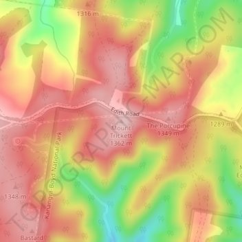
Nom : Carte topographique Mount Trickett, altitude, relief.

Lieu : Mount Trickett, Oberon Council, New South Wales, Australia (-33.83297 149.98354 -33.83287 149.98364)

Altitude moyenne : 1.284 m

Altitude minimum : 1.155 m

Altitude maximum : 1.360 m

Autres cartes topographiques

Cliquez sur une carte pour visualiser sa topographie, son altitude et son relief.

Sydney

Australia > New South Wales

Sydney's topography is characterized by a diverse landscape that seamlessly blends coastal features with inland plateaus. The city is divided into two primary regions: the relatively flat Cumberland Plain to the south and west of Sydney Harbour, and the elevated Hornsby Plateau to the north. The Cumberland…

Altitude moyenne : 53 m

Armidale

Australia > New South Wales

Altitude moyenne : 1.036 m

Newcastle

Australia > New South Wales

Altitude moyenne : 5 m

Wauchope

Australia > New South Wales

Altitude moyenne : 32 m

Pendle Creek

Australia > New South Wales > Sydney

Altitude moyenne : 43 m

St Ives

Australia > New South Wales

Altitude moyenne : 125 m

Albion Park

Australia > New South Wales

Altitude moyenne : 62 m

Port Macquarie

Australia > New South Wales

Altitude moyenne : 5 m

Baulkham Hills

Australia > New South Wales

Altitude moyenne : 93 m

Bonny Hills

Australia > New South Wales

Altitude moyenne : 15 m

Parkes Shire Council

Australia > New South Wales

Altitude moyenne : 307 m

Tumbarumba

Australia > New South Wales

Altitude moyenne : 774 m

Berry

Australia > New South Wales

Altitude moyenne : 38 m

Shoalhaven Heads

Australia > New South Wales

Altitude moyenne : 5 m

Lake Conjola

Australia > New South Wales

Altitude moyenne : 19 m

Bowral

Australia > New South Wales

Altitude moyenne : 690 m

Kyogle Council

Australia > New South Wales

Altitude moyenne : 315 m

Tweed Shire Council

Australia > New South Wales

Altitude moyenne : 212 m

Kingscliff

Australia > New South Wales

Altitude moyenne : 5 m

Old Bar

Australia > New South Wales

Altitude moyenne : 5 m

Anglers Reach

Australia > New South Wales

Altitude moyenne : 1.226 m

Macksville

Australia > New South Wales

Altitude moyenne : 10 m

Federation Council

Australia > New South Wales

Altitude moyenne : 143 m

Colo Heights

Australia > New South Wales

Altitude moyenne : 278 m

Central Coast Council

Australia > New South Wales

Altitude moyenne : 103 m

Mosman

Australia > New South Wales > Sydney

Altitude moyenne : 29 m

Penrith

Australia > New South Wales > Sydney > Penrith

Penrith is a city in New South Wales, Australia, located in Greater Western Sydney, 55 kilometres (31 mi) west of the Sydney central business district on the banks of the Nepean River, on the outskirts of the Cumberland Plain. Its elevation is 32 metres (105 ft).

Altitude moyenne : 34 m

Eastwood

Australia > New South Wales > Sydney

Altitude moyenne : 80 m

Glen Innes

Australia > New South Wales

Altitude moyenne : 1.083 m

North Sydney

Australia > New South Wales > Sydney

Altitude moyenne : 50 m

Bomaderry

Australia > New South Wales > Bomaderry

Altitude moyenne : 18 m

Glenning Valley

Australia > New South Wales > Gosford

Altitude moyenne : 50 m

Parramatta

Australia > New South Wales

Altitude moyenne : 22 m

Goulburn

Australia > New South Wales

Owing to its elevation, Goulburn has an oceanic climate (Cfb) with warm summers and cool winters; with a high diurnal range. Its climate is variable much of the year, though generally dry with maximum temperatures ranging from 11.8 °C (53.2 °F) in July to 28.3 °C (82.9 °F) in January. Rainfall is…

Altitude moyenne : 666 m

Merci de soutenir ce site ❤️
Faire un don

Équipez-vous pour votre prochaine aventure :

En tant que Partenaire Amazon, ce site perçoit une commission sur les achats éligibles sans surcoût pour vous.

Alstonville

Australia > New South Wales

Altitude moyenne : 131 m

Balmain

Australia > New South Wales > Sydney

Altitude moyenne : 12 m

Nowra

Australia > New South Wales

Altitude moyenne : 21 m

Manly Vale

Australia > New South Wales > Sydney

Altitude moyenne : 34 m

Moree

Australia > New South Wales

Altitude moyenne : 216 m

Windsor

Australia > New South Wales > Sydney

Altitude moyenne : 12 m

Hat Head

Australia > New South Wales

Altitude moyenne : 4 m

Coramba

Australia > New South Wales

Altitude moyenne : 182 m

Whalan

Australia > New South Wales > Sydney

Altitude moyenne : 48 m

Hill End

Australia > New South Wales

Altitude moyenne : 738 m

Merimbula

Australia > New South Wales

Altitude moyenne : 22 m

Blue Mountains

Australia > New South Wales

A sandstone plateau dominated by a landscape of endless eucalyptus forests, the Blue Mountains are located at the top of a 470-million-year-old quartzite. In the Permian period, a shallow sea covered the region, when rivers brought shales, siltstones and mudstones. Then during the Mesozoic period, rivers…

Altitude moyenne : 566 m

Inner West

Australia > New South Wales > Sydney

Altitude moyenne : 19 m

Emerald Beach

Australia > New South Wales

Altitude moyenne : 14 m

Tomaga River

Australia > New South Wales > Tomakin > Mogo

Altitude moyenne : 22 m

Eleebana

Australia > New South Wales > Newcastle

Altitude moyenne : 11 m

Wingham

Australia > New South Wales

Altitude moyenne : 47 m

Moruya

Australia > New South Wales

Altitude moyenne : 37 m

Rock Valley

Australia > New South Wales

Altitude moyenne : 92 m

Cooranbong

Australia > New South Wales

Altitude moyenne : 72 m

San Remo

Australia > New South Wales

Altitude moyenne : 16 m

Sydney

Australia > New South Wales

Sydney's topography is characterized by a diverse landscape that seamlessly blends coastal features with inland plateaus. The city is divided into two primary regions: the relatively flat Cumberland Plain to the south and west of Sydney Harbour, and the elevated Hornsby Plateau to the north. The Cumberland…

Altitude moyenne : 53 m

Yass

Australia > New South Wales

Yass is located 280 km south-west of Sydney, on the Hume Highway. The Yass River, which is a tributary of the Murrumbidgee River, flows through the town. Yass is 59 km from Canberra; lying at an elevation of 505 m AMSL.

Altitude moyenne : 533 m

Camden Council

Australia > New South Wales

Altitude moyenne : 90 m

Pittwater

Australia > New South Wales

Altitude moyenne : 45 m

New Lambton Heights

Australia > New South Wales

Altitude moyenne : 61 m

South Grafton

Australia > New South Wales

Altitude moyenne : 36 m

Blayney Shire Council

Australia > New South Wales

Altitude moyenne : 818 m

Illawarra

Australia > New South Wales

Altitude moyenne : 234 m

Hornsby

Australia > New South Wales > Sydney

Altitude moyenne : 160 m

Hunter River

Australia > New South Wales

Altitude moyenne : 344 m

Walcha

Australia > New South Wales

Altitude moyenne : 956 m

Manyana

Australia > New South Wales

Altitude moyenne : 17 m

Lismore

Australia > New South Wales

Altitude moyenne : 23 m

Cromer

Australia > New South Wales

Altitude moyenne : 46 m

Cabarita Beach

Australia > New South Wales

Altitude moyenne : 9 m

Yamba

Australia > New South Wales

Altitude moyenne : 2 m

Woodstock

Australia > New South Wales

Altitude moyenne : 501 m

Mirador

Australia > New South Wales

Altitude moyenne : 52 m

Cassilis

Australia > New South Wales

Altitude moyenne : 560 m

Tilba Tilba

Australia > New South Wales

Altitude moyenne : 84 m

Thora

Australia > New South Wales

Altitude moyenne : 190 m

Stockrington

Australia > New South Wales

Altitude moyenne : 85 m

Wandandian

Australia > New South Wales

Altitude moyenne : 60 m

Bowraville

Australia > New South Wales

Altitude moyenne : 33 m

Cougal

Australia > New South Wales

Altitude moyenne : 381 m

River Lett

Australia > New South Wales

Altitude moyenne : 804 m

Mount Victoria

Australia > New South Wales

Mount Victoria (postcode: 2786) is a small township in the Blue Mountains of New South Wales, Australia. Mount Victoria is geographically the western most village and suburb of Greater Sydney on the great western highway in the City of Blue Mountains, located about 120 kilometres (75 mi) west-northwest by road…

Altitude moyenne : 901 m

Urunga

Australia > New South Wales

Altitude moyenne : 13 m

Byron Bay

Australia > New South Wales

Byron Bay, located in northeastern New South Wales, Australia, is characterized by diverse topography shaped by its geological history. The town is part of the erosion caldera of the ancient Tweed Volcano, which erupted approximately 23 million years ago, resulting in the rich volcanic soils that define the…

Altitude moyenne : 7 m

Frenchs Forest

Australia > New South Wales > Sydney

Altitude moyenne : 110 m

Kulnura

Australia > New South Wales

Altitude moyenne : 203 m

Équipez-vous pour votre prochaine aventure :

Montres de Sport GPS - Données topographiques directement au poignet
🍳Popotes de Randonnée - Ustensiles légers pour cuisiner en plein air
🔦Lampes torches LED - Lampes puissantes pour activités nocturnes
🧭Altimètres baromètres - Mesure d'altitude et météo
🛰️GPS Garmin randonnée - GPS Garmin reconnus pour la randonnée et le trekking

En tant que Partenaire Amazon, ce site perçoit une commission sur les achats éligibles sans surcoût pour vous.