
Carte topographique Plamondon
Carte interactive
Cliquez sur la carte pour afficher l’altitude.
À propos de cette carte
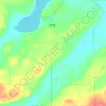
Nom : Carte topographique Plamondon, altitude, relief.
Lieu : Plamondon, Lac La Biche County, Alberta, T0A 2T0, Canada (54.84186 -112.35730 54.87828 -112.31327)
Altitude moyenne : 562 m
Altitude minimum : 541 m
Altitude maximum : 602 m
Autres cartes topographiques
Cliquez sur une carte pour visualiser sa topographie, son altitude et son relief.
Hamlet of Lac la Biche
Canada > Alberta > Lac La Biche County
Hamlet of Lac la Biche, Lac La Biche County, Alberta, Canada
Altitude moyenne : 550 m
Lac La Biche
Canada > Alberta > Lac La Biche County > Hamlet of Lac la Biche
Lac La Biche, Hamlet of Lac la Biche, Lac La Biche County, Alberta, Canada
Altitude moyenne : 563 m