
Carte topographique La Sal Mountains Viewpoint
Carte interactive
Cliquez sur la carte pour afficher l’altitude.
À propos de cette carte
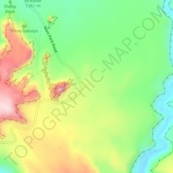
Nom : Carte topographique La Sal Mountains Viewpoint, altitude, relief.
Altitude moyenne : 1.347 m
Altitude minimum : 1.217 m
Altitude maximum : 1.522 m
Autres cartes topographiques
Cliquez sur une carte pour visualiser sa topographie, son altitude et son relief.
Canyonlands National Park - Maze District
Canyonlands National Park - Maze District, White Rim Road, San Juan County, Utah, USA
Altitude moyenne : 1.546 m
Long Valley Junction
USA > Utah > Long Valley Junction
Long Valley Junction, Kane County, Utah, 84710, USA
Altitude moyenne : 2.295 m
Thousand Lake Mountain
Thousand Lake Mountain, Wayne County, Utah, USA
Altitude moyenne : 3.341 m
Haystack Lake
Haystack Lake, Lakes Country Trail, Summit County, Utah, USA
Altitude moyenne : 3.067 m
Capitol Hill
USA > Utah > Salt Lake City
Capitol Hill, Salt Lake City, Salt Lake County, Utah, 84103, USA
Altitude moyenne : 1.510 m
Browns Park
Browns Park, Bountiful, Davis County, Utah, 84010, USA
Altitude moyenne : 1.556 m
Timpanogos Glacier
USA > Utah > Aspen Grove
Timpanogos Glacier, Mount Timpanogos Trail #052, Aspen Grove, Utah County, Utah, USA
Altitude moyenne : 3.148 m
Gladys Lake
Gladys Lake, Head of Rock Creek Trail, Duchesne County, Utah, USA
Altitude moyenne : 3.385 m
Little Bear River
Little Bear River, Cache County, Utah, 84319, USA
Altitude moyenne : 1.475 m