
Carte topographique Godwin Glacier
Carte interactive
Cliquez sur la carte pour afficher l’altitude.
À propos de cette carte
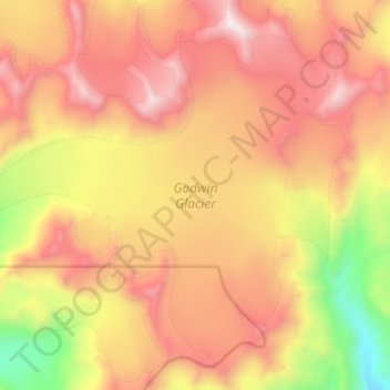
Nom : Carte topographique Godwin Glacier, altitude, relief.
Lieu : Godwin Glacier, Kenai Peninsula, Alaska, USA (60.09434 -149.27053 60.15752 -149.11710)
Altitude moyenne : 1.023 m
Altitude minimum : 114 m
Altitude maximum : 1.752 m
Autres cartes topographiques
Cliquez sur une carte pour visualiser sa topographie, son altitude et son relief.
Gannett Glacier
Gannett Glacier, Unorganized Borough, Alaska, USA
Altitude moyenne : 1.571 m
Admiralty Island
Admiralty Island, Hoonah-Angoon, Alaska, 99820, USA
Altitude moyenne : 295 m
Eldridge Glacier
Eldridge Glacier, Matanuska-Susitna, Alaska, USA
Altitude moyenne : 1.074 m
Gulkana Glacier
Gulkana Glacier, Unorganized Borough, Alaska, USA
Altitude moyenne : 1.691 m
Kennicott Glacier
Kennicott Glacier, Valdez-Cordova, Alaska, USA
Altitude moyenne : 1.845 m
Revillagigedo Island
Revillagigedo Island, Ketchikan Gateway, Alaska, USA
Altitude moyenne : 342 m
Grewingk Glacier
Grewingk Glacier, Kenai Peninsula, Alaska, USA
Altitude moyenne : 1.008 m
Tokositna Glacier
Tokositna Glacier, Matanuska-Susitna, Alaska, USA
Altitude moyenne : 1.485 m
Chugach Mountains
Chugach Mountains, Matanuska-Susitna, Alaska, USA
Altitude moyenne : 2.530 m
Exit Glacier
Exit Glacier, Harding Ice Field Approach Trail, Kenai Peninsula, Alaska, USA
Altitude moyenne : 1.092 m
Kuskokwim River
Kuskokwim River, Unorganized Borough, Alaska, USA
Altitude moyenne : 111 m
Kanikula Glacier
Kanikula Glacier, Matanuska-Susitna, Alaska, USA
Altitude moyenne : 1.606 m
Caldwell Glacier
Caldwell Glacier, Matanuska-Susitna, Alaska, USA
Altitude moyenne : 1.569 m
Martin River Glacier
Martin River Glacier, Valdez-Cordova, Alaska, USA
Altitude moyenne : 844 m