

Faire un don
Équipez-vous pour votre prochaine aventure :
En tant que Partenaire Amazon, ce site perçoit une commission sur les achats éligibles sans surcoût pour vous.
Carte topographique Ittigen
Cliquez sur la carte pour afficher l’altitude.
Faire un don
Équipez-vous pour votre prochaine aventure :
En tant que Partenaire Amazon, ce site perçoit une commission sur les achats éligibles sans surcoût pour vous.
Ittigen
The municipality is located in the Worblental (Worblen valley) on a terrace on the Mannenberg (elevation 688 m [2,257 ft]) in the agglomeration of Bern.
Faire un don
Équipez-vous pour votre prochaine aventure :
En tant que Partenaire Amazon, ce site perçoit une commission sur les achats éligibles sans surcoût pour vous.
À propos de cette carte
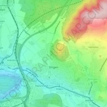
Nom : Carte topographique Ittigen, altitude, relief.
Altitude moyenne : 595 m
Altitude minimum : 493 m
Altitude maximum : 811 m
Faire un don
Équipez-vous pour votre prochaine aventure :
En tant que Partenaire Amazon, ce site perçoit une commission sur les achats éligibles sans surcoût pour vous.
Autres cartes topographiques
Cliquez sur une carte pour visualiser sa topographie, son altitude et son relief.
Oberdettigen
Switzerland > Bern > Bern-Mittelland administrative district > Hinterkappelen
Altitude moyenne : 566 m
Bern
Switzerland > Bern > Bern-Mittelland administrative district > Bern
Bern is built on very uneven ground. An elevation difference of up to 60 metres exists between the inner city districts on the Aare (Matte, Marzili) and the higher ones (Kirchenfeld, Länggasse).
Altitude moyenne : 643 m
Hofen
Switzerland > Bern > Bern-Mittelland administrative district > Wohlen bei Bern
Altitude moyenne : 569 m