
Carte topographique São Jorge
Carte interactive
Cliquez sur la carte pour afficher l’altitude.
À propos de cette carte
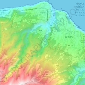
Nom : Carte topographique São Jorge, altitude, relief.
Lieu : São Jorge, Santana, Madeira, 9230-142, Portugal (32.76174 -16.96055 32.83761 -16.89639)
Altitude moyenne : 581 m
Altitude minimum : -1 m
Altitude maximum : 1.767 m
Fifty kilometres from the regional capital, the parish is located 240 metres above sea level, limited in the north by the Atlantic Ocean and south by the mountains of the interior range (the heightest altitudes in the parish include Pico Canário 1,592 metres (5,223 ft) and Pico dos Assumadouros 1,184 metres (3,885 ft). To the west is the civil parish of Arco de São Jorge and east are the parishes of Ilha and Santana. About half of the parish is covered by the rich Laurissilva forest defined as Natural Heritage by UNESCO.
Autres cartes topographiques
Cliquez sur une carte pour visualiser sa topographie, son altitude et son relief.
São Roque do Faial
São Roque do Faial, Santana, Madeira, Portugal
Altitude moyenne : 632 m
Praia de S. Jorge
Portugal > Santana > Calhau São Jorge
Praia de S. Jorge, Calhau, Calhau São Jorge, Santana, 9230-111, Portugal
Altitude moyenne : 121 m